|
|
|||||||||||||||||
| Point ID: 272 | Downloads | Plots | Site Data | Code: 05BF025 |
|
|
|||||||||||||||||
| Download | |
|---|---|
| Site Descriptor Information | Site Time Series Data |
| Link to all available data | |
| View: | Time Series | All |
| Units: | m3/s |
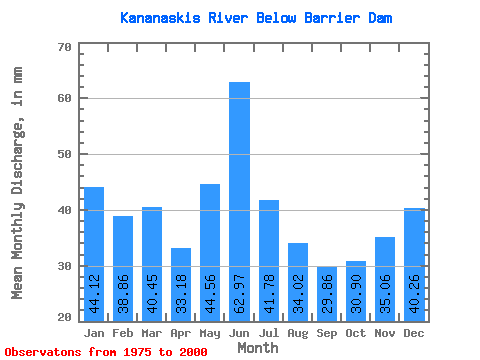
| Statistic | Jan | Feb | Mar | Apr | May | Jun | Jul | Aug | Sep | Oct | Nov | Dec | Annual |
|---|---|---|---|---|---|---|---|---|---|---|---|---|---|
| Mean | 44.11 | 39.19 | 40.45 | 33.18 | 44.55 | 62.98 | 41.78 | 34.01 | 29.86 | 30.90 | 35.06 | 40.25 | 476.78 |
| Standard Deviation | 8.57 | 7.58 | 10.51 | 13.77 | 15.38 | 31.90 | 20.66 | 12.68 | 9.50 | 8.16 | 10.71 | 9.20 | 86.95 |
| Min | 26.00 | 16.15 | 10.90 | 0.33 | 20.58 | 27.54 | 13.61 | 17.46 | 13.87 | 17.01 | 17.70 | 25.83 | 347.08 |
| Max | 63.15 | 56.45 | 58.98 | 58.24 | 73.88 | 144.16 | 86.98 | 59.28 | 52.76 | 47.07 | 57.95 | 71.49 | 664.08 |
| Coefficient of Variation | 0.19 | 0.19 | 0.26 | 0.41 | 0.34 | 0.51 | 0.49 | 0.37 | 0.32 | 0.26 | 0.30 | 0.23 | 0.18 |
 Return to R-Arctic Net Home Page