|
|
|||||||||||||||||
| Point ID: 26 | Downloads | Plots | Site Data | Code: 05AA909 |
|
|
|||||||||||||||||
| Download | |
|---|---|
| Site Descriptor Information | Site Time Series Data |
| Link to all available data | |
| View: | Time Series | All |
| Units: | mm |
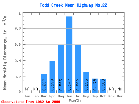
| Statistic | Jan | Feb | Mar | Apr | May | Jun | Jul | Aug | Sep | Oct | Nov | Dec | Annual |
|---|---|---|---|---|---|---|---|---|---|---|---|---|---|
| Mean | 0.24 | 0.40 | 0.59 | 0.95 | 0.59 | 0.26 | 0.18 | 0.17 | |||||
| Standard Deviation | 0.13 | 0.23 | 0.46 | 0.91 | 0.68 | 0.22 | 0.13 | 0.11 | |||||
| Min | 0.12 | 0.09 | 0.06 | 0.17 | 0.09 | 0.06 | 0.04 | 0.04 | |||||
| Max | 0.37 | 0.85 | 1.70 | 3.35 | 2.89 | 1.00 | 0.63 | 0.52 | |||||
| Coefficient of Variation | 0.55 | 0.58 | 0.78 | 0.96 | 1.15 | 0.86 | 0.72 | 0.64 |
 Return to R-Arctic Net Home Page