|
|
|||||||||||||||||
| Point ID: 26 | Downloads | Plots | Site Data | Code: 05AA909 |
|
|
|||||||||||||||||
| Download | |
|---|---|
| Site Descriptor Information | Site Time Series Data |
| Link to all available data | |
| View: | Time Series | All |
| Units: | m3/s |
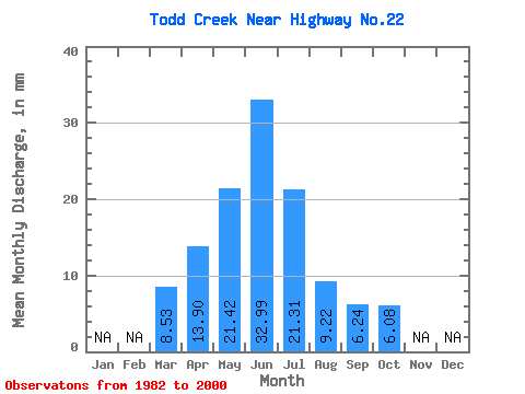
| Statistic | Jan | Feb | Mar | Apr | May | Jun | Jul | Aug | Sep | Oct | Nov | Dec | Annual |
|---|---|---|---|---|---|---|---|---|---|---|---|---|---|
| Mean | 8.52 | 13.90 | 21.41 | 33.00 | 21.33 | 9.21 | 6.24 | 6.10 | |||||
| Standard Deviation | 4.67 | 8.06 | 16.59 | 31.82 | 24.53 | 7.92 | 4.48 | 3.91 | |||||
| Min | 4.17 | 3.03 | 1.98 | 5.75 | 3.13 | 2.12 | 1.32 | 1.55 | |||||
| Max | 13.46 | 29.65 | 61.19 | 116.71 | 104.02 | 35.99 | 21.88 | 18.54 | |||||
| Coefficient of Variation | 0.55 | 0.58 | 0.78 | 0.96 | 1.15 | 0.86 | 0.72 | 0.64 |
 Return to R-Arctic Net Home Page