|
|
|||||||||||||||||
| Point ID: 253 | Downloads | Plots | Site Data | Code: 05BE008 |
|
|
|||||||||||||||||
| Download | |
|---|---|
| Site Descriptor Information | Site Time Series Data |
| Link to all available data | |
| View: | Time Series | All |
| Units: | mm |
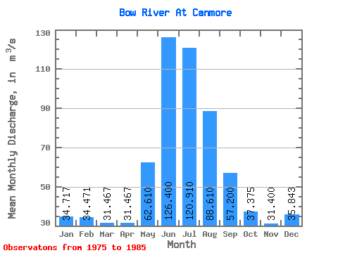
| Statistic | Jan | Feb | Mar | Apr | May | Jun | Jul | Aug | Sep | Oct | Nov | Dec | Annual |
|---|---|---|---|---|---|---|---|---|---|---|---|---|---|
| Mean | 34.72 | 34.47 | 31.47 | 31.47 | 62.61 | 126.40 | 120.91 | 88.61 | 57.20 | 37.38 | 31.40 | 35.84 | 52.39 |
| Standard Deviation | 9.28 | 8.25 | 9.40 | 9.10 | 35.27 | 18.55 | 36.58 | 30.30 | 14.64 | 6.65 | 9.60 | 8.71 | 1.77 |
| Min | 18.50 | 18.20 | 18.60 | 23.90 | 27.70 | 106.00 | 79.50 | 66.90 | 43.90 | 27.00 | 14.50 | 19.00 | 51.24 |
| Max | 42.80 | 44.30 | 43.10 | 44.40 | 129.00 | 151.00 | 202.00 | 159.00 | 90.90 | 47.80 | 41.70 | 44.40 | 54.43 |
| Coefficient of Variation | 0.27 | 0.24 | 0.30 | 0.29 | 0.56 | 0.15 | 0.30 | 0.34 | 0.26 | 0.18 | 0.31 | 0.24 | 0.03 |
 Return to R-Arctic Net Home Page