|
|
|||||||||||||||||
| Point ID: 253 | Downloads | Plots | Site Data | Code: 05BE008 |
|
|
|||||||||||||||||
| Download | |
|---|---|
| Site Descriptor Information | Site Time Series Data |
| Link to all available data | |
| View: | Time Series | All |
| Units: | m3/s |
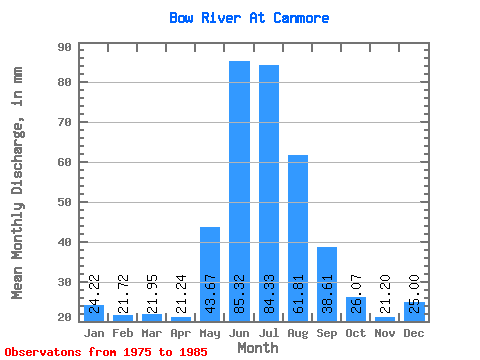
| Statistic | Jan | Feb | Mar | Apr | May | Jun | Jul | Aug | Sep | Oct | Nov | Dec | Annual |
|---|---|---|---|---|---|---|---|---|---|---|---|---|---|
| Mean | 24.21 | 21.90 | 21.95 | 21.24 | 43.66 | 85.32 | 84.32 | 61.80 | 38.61 | 26.07 | 21.20 | 25.00 | 430.59 |
| Standard Deviation | 6.47 | 5.24 | 6.55 | 6.14 | 24.60 | 12.52 | 25.51 | 21.13 | 9.88 | 4.64 | 6.48 | 6.08 | 14.57 |
| Min | 12.90 | 11.56 | 12.97 | 16.13 | 19.32 | 71.55 | 55.44 | 46.66 | 29.63 | 18.83 | 9.79 | 13.25 | 421.14 |
| Max | 29.85 | 28.15 | 30.06 | 29.97 | 89.96 | 101.92 | 140.87 | 110.89 | 61.36 | 33.34 | 28.15 | 30.96 | 447.37 |
| Coefficient of Variation | 0.27 | 0.24 | 0.30 | 0.29 | 0.56 | 0.15 | 0.30 | 0.34 | 0.26 | 0.18 | 0.31 | 0.24 | 0.03 |
 Return to R-Arctic Net Home Page