|
|
|||||||||||||||||
| Point ID: 251 | Downloads | Plots | Site Data | Code: 05BE006 |
|
|
|||||||||||||||||
| Download | |
|---|---|
| Site Descriptor Information | Site Time Series Data |
| Link to all available data | |
| View: | Time Series | All |
| Units: | mm |
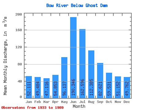
| Statistic | Jan | Feb | Mar | Apr | May | Jun | Jul | Aug | Sep | Oct | Nov | Dec | Annual |
|---|---|---|---|---|---|---|---|---|---|---|---|---|---|
| Mean | 52.11 | 49.48 | 47.12 | 54.85 | 96.14 | 190.35 | 162.60 | 112.39 | 82.62 | 59.53 | 51.15 | 49.76 | 85.11 |
| Standard Deviation | 13.47 | 14.34 | 12.23 | 17.10 | 33.64 | 53.55 | 46.29 | 25.98 | 17.17 | 11.45 | 11.07 | 12.15 | 14.09 |
| Min | 20.90 | 25.50 | 26.00 | 26.80 | 42.60 | 116.00 | 88.70 | 78.70 | 60.80 | 39.10 | 32.30 | 27.40 | 57.08 |
| Max | 73.80 | 77.30 | 77.20 | 88.80 | 193.00 | 323.00 | 295.00 | 196.00 | 142.00 | 96.40 | 79.00 | 78.60 | 115.61 |
| Coefficient of Variation | 0.26 | 0.29 | 0.26 | 0.31 | 0.35 | 0.28 | 0.28 | 0.23 | 0.21 | 0.19 | 0.22 | 0.24 | 0.17 |
 Return to R-Arctic Net Home Page