|
|
|||||||||||||||||
| Point ID: 251 | Downloads | Plots | Site Data | Code: 05BE006 |
|
|
|||||||||||||||||
| Download | |
|---|---|
| Site Descriptor Information | Site Time Series Data |
| Link to all available data | |
| View: | Time Series | All |
| Units: | m3/s |
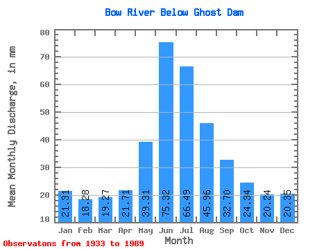
| Statistic | Jan | Feb | Mar | Apr | May | Jun | Jul | Aug | Sep | Oct | Nov | Dec | Annual |
|---|---|---|---|---|---|---|---|---|---|---|---|---|---|
| Mean | 21.31 | 18.43 | 19.26 | 21.71 | 39.31 | 75.33 | 66.48 | 45.95 | 32.70 | 24.34 | 20.24 | 20.35 | 410.08 |
| Standard Deviation | 5.51 | 5.34 | 5.00 | 6.77 | 13.76 | 21.19 | 18.93 | 10.62 | 6.79 | 4.68 | 4.38 | 4.97 | 67.91 |
| Min | 8.54 | 9.50 | 10.63 | 10.61 | 17.42 | 45.90 | 36.27 | 32.18 | 24.06 | 15.99 | 12.78 | 11.20 | 275.01 |
| Max | 30.17 | 28.80 | 31.56 | 35.14 | 78.91 | 127.82 | 120.61 | 80.14 | 56.19 | 39.41 | 31.26 | 32.14 | 557.04 |
| Coefficient of Variation | 0.26 | 0.29 | 0.26 | 0.31 | 0.35 | 0.28 | 0.28 | 0.23 | 0.21 | 0.19 | 0.22 | 0.24 | 0.17 |
 Return to R-Arctic Net Home Page