|
|
|||||||||||||||||
| Point ID: 25 | Downloads | Plots | Site Data | Code: 05AA030 |
|
|
|||||||||||||||||
| Download | |
|---|---|
| Site Descriptor Information | Site Time Series Data |
| Link to all available data | |
| View: | Time Series | All |
| Units: | mm |
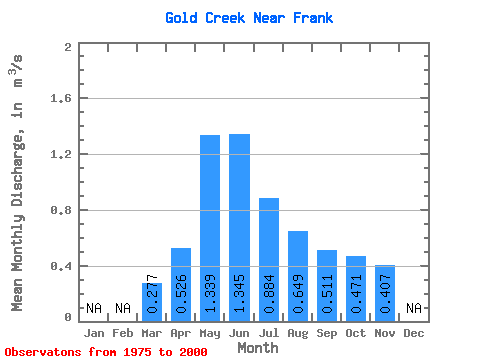
| Statistic | Jan | Feb | Mar | Apr | May | Jun | Jul | Aug | Sep | Oct | Nov | Dec | Annual |
|---|---|---|---|---|---|---|---|---|---|---|---|---|---|
| Mean | 0.28 | 0.53 | 1.34 | 1.34 | 0.88 | 0.65 | 0.51 | 0.47 | 0.41 | ||||
| Standard Deviation | 0.19 | 0.70 | 0.88 | 0.58 | 0.41 | 0.18 | 0.13 | 0.10 | |||||
| Min | 0.28 | 0.29 | 0.31 | 0.35 | 0.29 | 0.26 | 0.31 | 0.29 | 0.26 | ||||
| Max | 0.28 | 0.91 | 2.84 | 3.42 | 2.69 | 2.08 | 1.16 | 0.87 | 0.59 | ||||
| Coefficient of Variation | 0.36 | 0.52 | 0.66 | 0.66 | 0.63 | 0.35 | 0.28 | 0.25 |
 Return to R-Arctic Net Home Page