|
|
|||||||||||||||||
| Point ID: 25 | Downloads | Plots | Site Data | Code: 05AA030 |
|
|
|||||||||||||||||
| Download | |
|---|---|
| Site Descriptor Information | Site Time Series Data |
| Link to all available data | |
| View: | Time Series | All |
| Units: | m3/s |
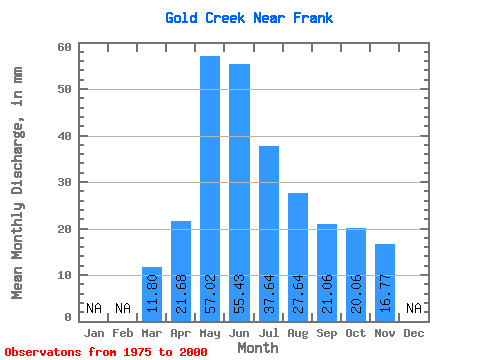
| Statistic | Jan | Feb | Mar | Apr | May | Jun | Jul | Aug | Sep | Oct | Nov | Dec | Annual |
|---|---|---|---|---|---|---|---|---|---|---|---|---|---|
| Mean | 11.79 | 21.66 | 57.01 | 55.42 | 37.65 | 27.65 | 21.07 | 20.07 | 16.76 | ||||
| Standard Deviation | 7.90 | 29.83 | 36.32 | 24.65 | 17.30 | 7.46 | 5.55 | 4.16 | |||||
| Min | 11.79 | 11.95 | 13.11 | 14.55 | 12.47 | 10.94 | 12.82 | 12.26 | 10.51 | ||||
| Max | 11.79 | 37.62 | 120.91 | 140.93 | 114.53 | 88.56 | 47.80 | 37.17 | 24.35 | ||||
| Coefficient of Variation | 0.36 | 0.52 | 0.66 | 0.66 | 0.63 | 0.35 | 0.28 | 0.25 |
 Return to R-Arctic Net Home Page