|
|
|||||||||||||||||
| Point ID: 249 | Downloads | Plots | Site Data | Code: 05BE003 |
|
|
|||||||||||||||||
| Download | |
|---|---|
| Site Descriptor Information | Site Time Series Data |
| Link to all available data | |
| View: | Time Series | All |
| Units: | mm |
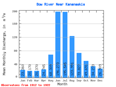
| Statistic | Jan | Feb | Mar | Apr | May | Jun | Jul | Aug | Sep | Oct | Nov | Dec | Annual |
|---|---|---|---|---|---|---|---|---|---|---|---|---|---|
| Mean | 23.36 | 20.17 | 20.37 | 24.75 | 68.31 | 196.27 | 195.54 | 123.99 | 73.83 | 49.69 | 34.27 | 26.91 | 71.52 |
| Standard Deviation | 4.35 | 3.28 | 4.34 | 7.25 | 15.87 | 44.51 | 61.60 | 22.27 | 15.82 | 8.88 | 6.10 | 6.86 | 8.92 |
| Min | 17.80 | 16.90 | 15.70 | 15.30 | 34.80 | 131.00 | 123.00 | 99.90 | 48.40 | 37.40 | 26.50 | 18.30 | 61.31 |
| Max | 31.60 | 27.70 | 30.10 | 37.50 | 94.80 | 261.00 | 307.00 | 168.00 | 99.10 | 61.20 | 45.10 | 39.60 | 92.30 |
| Coefficient of Variation | 0.19 | 0.16 | 0.21 | 0.29 | 0.23 | 0.23 | 0.32 | 0.18 | 0.21 | 0.18 | 0.18 | 0.26 | 0.12 |
 Return to R-Arctic Net Home Page