|
|
|||||||||||||||||
| Point ID: 249 | Downloads | Plots | Site Data | Code: 05BE003 |
|
|
|||||||||||||||||
| Download | |
|---|---|
| Site Descriptor Information | Site Time Series Data |
| Link to all available data | |
| View: | Time Series | All |
| Units: | m3/s |
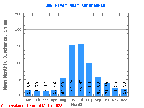
| Statistic | Jan | Feb | Mar | Apr | May | Jun | Jul | Aug | Sep | Oct | Nov | Dec | Annual |
|---|---|---|---|---|---|---|---|---|---|---|---|---|---|
| Mean | 15.04 | 11.83 | 13.11 | 15.42 | 43.97 | 122.29 | 125.88 | 79.82 | 46.00 | 31.99 | 21.36 | 17.32 | 542.60 |
| Standard Deviation | 2.80 | 1.92 | 2.79 | 4.52 | 10.22 | 27.73 | 39.66 | 14.34 | 9.85 | 5.71 | 3.80 | 4.41 | 67.67 |
| Min | 11.46 | 9.91 | 10.11 | 9.53 | 22.40 | 81.62 | 79.18 | 64.31 | 30.16 | 24.08 | 16.51 | 11.78 | 465.12 |
| Max | 20.34 | 16.25 | 19.38 | 23.36 | 61.03 | 162.62 | 197.63 | 108.15 | 61.75 | 39.40 | 28.10 | 25.49 | 700.24 |
| Coefficient of Variation | 0.19 | 0.16 | 0.21 | 0.29 | 0.23 | 0.23 | 0.32 | 0.18 | 0.21 | 0.18 | 0.18 | 0.26 | 0.12 |
 Return to R-Arctic Net Home Page