|
|
|||||||||||||||||
| Point ID: 240 | Downloads | Plots | Site Data | Code: 05BC003 |
|
|
|||||||||||||||||
| Download | |
|---|---|
| Site Descriptor Information | Site Time Series Data |
| Link to all available data | |
| View: | Time Series | All |
| Units: | mm |
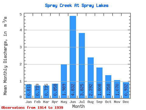
| Statistic | Jan | Feb | Mar | Apr | May | Jun | Jul | Aug | Sep | Oct | Nov | Dec | Annual |
|---|---|---|---|---|---|---|---|---|---|---|---|---|---|
| Mean | 0.81 | 0.74 | 0.73 | 0.86 | 1.99 | 4.83 | 3.83 | 2.39 | 1.81 | 1.36 | 1.07 | 0.93 | 1.75 |
| Standard Deviation | 0.15 | 0.14 | 0.14 | 0.17 | 0.65 | 1.72 | 2.20 | 0.90 | 0.70 | 0.34 | 0.21 | 0.16 | 0.38 |
| Min | 0.62 | 0.58 | 0.59 | 0.61 | 1.20 | 2.09 | 1.75 | 1.23 | 0.94 | 0.91 | 0.77 | 0.71 | 1.21 |
| Max | 1.11 | 1.02 | 1.12 | 1.09 | 3.77 | 8.58 | 12.10 | 4.97 | 4.04 | 2.27 | 1.49 | 1.18 | 2.50 |
| Coefficient of Variation | 0.18 | 0.18 | 0.19 | 0.20 | 0.33 | 0.36 | 0.57 | 0.37 | 0.39 | 0.25 | 0.20 | 0.17 | 0.21 |
 Return to R-Arctic Net Home Page