|
|
|||||||||||||||||
| Point ID: 240 | Downloads | Plots | Site Data | Code: 05BC003 |
|
|
|||||||||||||||||
| Download | |
|---|---|
| Site Descriptor Information | Site Time Series Data |
| Link to all available data | |
| View: | Time Series | All |
| Units: | m3/s |
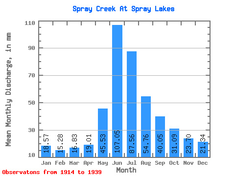
| Statistic | Jan | Feb | Mar | Apr | May | Jun | Jul | Aug | Sep | Oct | Nov | Dec | Annual |
|---|---|---|---|---|---|---|---|---|---|---|---|---|---|
| Mean | 18.57 | 15.41 | 16.83 | 19.02 | 45.53 | 107.04 | 87.55 | 54.74 | 40.05 | 31.07 | 23.70 | 21.33 | 472.49 |
| Standard Deviation | 3.43 | 2.86 | 3.12 | 3.83 | 14.91 | 38.13 | 50.27 | 20.49 | 15.59 | 7.82 | 4.69 | 3.65 | 101.09 |
| Min | 14.24 | 12.07 | 13.62 | 13.49 | 27.47 | 46.30 | 40.06 | 28.15 | 20.80 | 20.71 | 16.95 | 16.18 | 326.17 |
| Max | 25.41 | 21.27 | 25.64 | 24.15 | 86.29 | 190.08 | 276.96 | 113.76 | 89.50 | 51.96 | 33.01 | 27.01 | 674.61 |
| Coefficient of Variation | 0.18 | 0.18 | 0.19 | 0.20 | 0.33 | 0.36 | 0.57 | 0.37 | 0.39 | 0.25 | 0.20 | 0.17 | 0.21 |
 Return to R-Arctic Net Home Page