|
|
|||||||||||||||||
| Point ID: 235 | Downloads | Plots | Site Data | Code: 05BB003 |
|
|
|||||||||||||||||
| Download | |
|---|---|
| Site Descriptor Information | Site Time Series Data |
| Link to all available data | |
| View: | Time Series | All |
| Units: | mm |
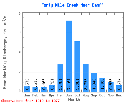
| Statistic | Jan | Feb | Mar | Apr | May | Jun | Jul | Aug | Sep | Oct | Nov | Dec | Annual |
|---|---|---|---|---|---|---|---|---|---|---|---|---|---|
| Mean | 0.57 | 0.52 | 0.47 | 0.72 | 2.78 | 7.16 | 5.08 | 2.80 | 1.95 | 1.41 | 1.00 | 0.67 | 2.12 |
| Standard Deviation | 0.17 | 0.12 | 0.14 | 0.20 | 1.20 | 2.12 | 1.62 | 0.69 | 0.56 | 0.36 | 0.28 | 0.18 | 0.39 |
| Min | 0.22 | 0.30 | 0.33 | 0.38 | 1.11 | 3.46 | 2.83 | 1.93 | 1.35 | 0.73 | 0.51 | 0.30 | 1.55 |
| Max | 0.82 | 0.71 | 0.79 | 1.05 | 5.62 | 10.40 | 8.87 | 4.10 | 3.06 | 1.95 | 1.29 | 0.92 | 2.59 |
| Coefficient of Variation | 0.30 | 0.24 | 0.29 | 0.28 | 0.43 | 0.29 | 0.32 | 0.25 | 0.29 | 0.26 | 0.28 | 0.27 | 0.18 |
 Return to R-Arctic Net Home Page