|
|
|||||||||||||||||
| Point ID: 235 | Downloads | Plots | Site Data | Code: 05BB003 |
|
|
|||||||||||||||||
| Download | |
|---|---|
| Site Descriptor Information | Site Time Series Data |
| Link to all available data | |
| View: | Time Series | All |
| Units: | m3/s |
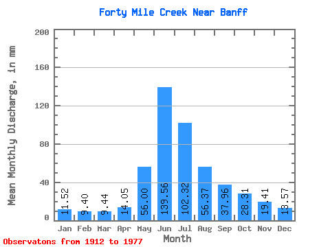
| Statistic | Jan | Feb | Mar | Apr | May | Jun | Jul | Aug | Sep | Oct | Nov | Dec | Annual |
|---|---|---|---|---|---|---|---|---|---|---|---|---|---|
| Mean | 11.52 | 9.49 | 9.44 | 14.06 | 55.99 | 139.55 | 102.31 | 56.37 | 37.95 | 28.31 | 19.40 | 13.57 | 502.33 |
| Standard Deviation | 3.44 | 2.28 | 2.71 | 3.98 | 24.07 | 41.23 | 32.64 | 13.99 | 10.93 | 7.36 | 5.44 | 3.65 | 92.80 |
| Min | 4.45 | 5.59 | 6.72 | 7.39 | 22.35 | 67.43 | 56.98 | 38.86 | 26.31 | 14.78 | 9.88 | 6.12 | 368.16 |
| Max | 16.45 | 13.06 | 15.97 | 20.46 | 113.16 | 202.68 | 178.60 | 82.56 | 59.63 | 39.26 | 25.14 | 18.61 | 615.10 |
| Coefficient of Variation | 0.30 | 0.24 | 0.29 | 0.28 | 0.43 | 0.29 | 0.32 | 0.25 | 0.29 | 0.26 | 0.28 | 0.27 | 0.18 |
 Return to R-Arctic Net Home Page