|
|
|||||||||||||||||
| Point ID: 23 | Downloads | Plots | Site Data | Code: 05AA028 |
|
|
|||||||||||||||||
| Download | |
|---|---|
| Site Descriptor Information | Site Time Series Data |
| Link to all available data | |
| View: | Time Series | All |
| Units: | mm |
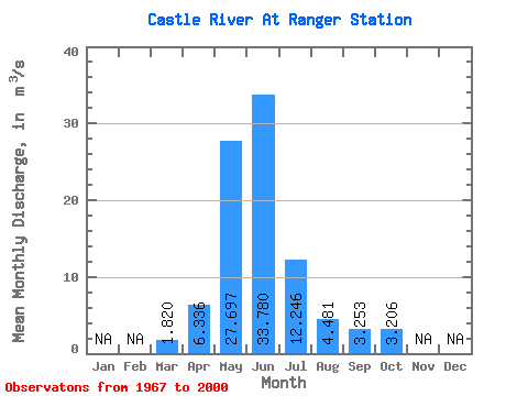
| Statistic | Jan | Feb | Mar | Apr | May | Jun | Jul | Aug | Sep | Oct | Nov | Dec | Annual |
|---|---|---|---|---|---|---|---|---|---|---|---|---|---|
| Mean | 1.82 | 6.34 | 27.70 | 33.78 | 12.25 | 4.48 | 3.25 | 3.21 | |||||
| Standard Deviation | 1.13 | 3.10 | 7.20 | 16.39 | 5.70 | 1.73 | 1.46 | 1.79 | |||||
| Min | 0.61 | 1.19 | 12.90 | 8.72 | 2.95 | 2.10 | 1.70 | 1.41 | |||||
| Max | 6.65 | 12.40 | 41.90 | 74.10 | 25.30 | 9.76 | 7.71 | 9.71 | |||||
| Coefficient of Variation | 0.62 | 0.49 | 0.26 | 0.48 | 0.47 | 0.39 | 0.45 | 0.56 |
 Return to R-Arctic Net Home Page