|
|
|||||||||||||||||
| Point ID: 23 | Downloads | Plots | Site Data | Code: 05AA028 |
|
|
|||||||||||||||||
| Download | |
|---|---|
| Site Descriptor Information | Site Time Series Data |
| Link to all available data | |
| View: | Time Series | All |
| Units: | m3/s |
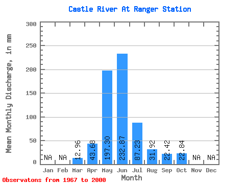
| Statistic | Jan | Feb | Mar | Apr | May | Jun | Jul | Aug | Sep | Oct | Nov | Dec | Annual |
|---|---|---|---|---|---|---|---|---|---|---|---|---|---|
| Mean | 12.96 | 43.68 | 197.27 | 232.87 | 87.22 | 31.91 | 22.42 | 22.83 | |||||
| Standard Deviation | 8.06 | 21.40 | 51.26 | 113.01 | 40.59 | 12.29 | 10.07 | 12.72 | |||||
| Min | 4.34 | 8.20 | 91.88 | 60.11 | 21.01 | 14.96 | 11.72 | 10.04 | |||||
| Max | 47.36 | 85.48 | 298.43 | 510.82 | 180.19 | 69.51 | 53.15 | 69.16 | |||||
| Coefficient of Variation | 0.62 | 0.49 | 0.26 | 0.48 | 0.47 | 0.39 | 0.45 | 0.56 |
 Return to R-Arctic Net Home Page