|
|
|||||||||||||||||
| Point ID: 229 | Downloads | Plots | Site Data | Code: 05BA007 |
|
|
|||||||||||||||||
| Download | |
|---|---|
| Site Descriptor Information | Site Time Series Data |
| Link to all available data | |
| View: | Time Series | All |
| Units: | mm |
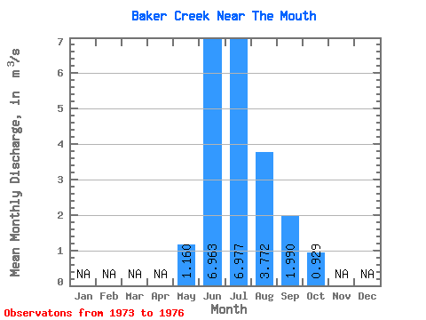
| Statistic | Jan | Feb | Mar | Apr | May | Jun | Jul | Aug | Sep | Oct | Nov | Dec | Annual |
|---|---|---|---|---|---|---|---|---|---|---|---|---|---|
| Mean | 1.16 | 6.96 | 6.98 | 3.77 | 1.99 | 0.93 | |||||||
| Standard Deviation | 0.10 | 2.53 | 1.69 | 1.50 | 1.15 | 0.20 | |||||||
| Min | 1.09 | 5.37 | 5.22 | 2.58 | 1.29 | 0.74 | |||||||
| Max | 1.23 | 9.88 | 8.60 | 5.95 | 3.70 | 1.21 | |||||||
| Coefficient of Variation | 0.09 | 0.36 | 0.24 | 0.40 | 0.58 | 0.21 |
 Return to R-Arctic Net Home Page