|
|
| Point ID: 229 | Downloads | Plots | Site Data | Code: 05BA007 |
|
| Download | |
|---|---|
| Site Descriptor Information | Site Time Series Data |
| Link to all available data | |
|
|
|
| View: | Statistics | All |
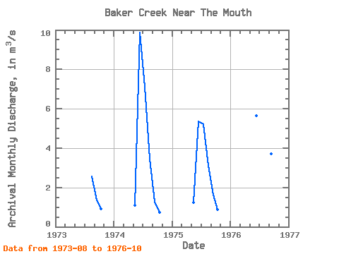
| Units: | mm |
| Year | Jan | Feb | Mar | Apr | May | Jun | Jul | Aug | Sep | Oct | Nov | Dec | Annual | 1973 | 2.58 | 1.33 | 0.90 | 1974 | 1.09 | 9.88 | 7.11 | 3.45 | 1.29 | 0.74 | 1975 | 1.23 | 5.37 | 5.22 | 3.11 | 1.64 | 0.86 | 1976 | 5.64 | 8.60 | 5.95 | 3.70 | 1.21 |
|---|
 Return to R-Arctic Net Home Page