|
|
|||||||||||||||||
| Point ID: 218 | Downloads | Plots | Site Data | Code: 05AJ001 |
|
|
|||||||||||||||||
| Download | |
|---|---|
| Site Descriptor Information | Site Time Series Data |
| Link to all available data | |
| View: | Time Series | All |
| Units: | mm |
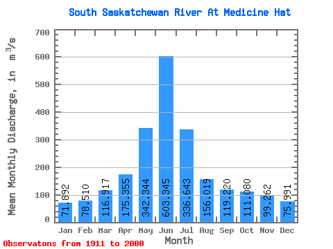
| Statistic | Jan | Feb | Mar | Apr | May | Jun | Jul | Aug | Sep | Oct | Nov | Dec | Annual |
|---|---|---|---|---|---|---|---|---|---|---|---|---|---|
| Mean | 71.89 | 78.51 | 116.92 | 175.35 | 342.34 | 603.35 | 336.64 | 156.02 | 119.22 | 111.08 | 99.26 | 75.99 | 190.66 |
| Standard Deviation | 23.91 | 26.10 | 46.56 | 90.05 | 171.71 | 323.58 | 216.15 | 102.98 | 98.06 | 67.68 | 37.31 | 25.06 | 73.67 |
| Min | 30.20 | 33.60 | 47.30 | 28.90 | 40.40 | 80.10 | 35.60 | 37.10 | 23.40 | 18.10 | 36.10 | 26.70 | 65.42 |
| Max | 197.00 | 149.00 | 270.00 | 559.00 | 1020.00 | 1640.00 | 1070.00 | 523.00 | 628.00 | 401.00 | 263.00 | 151.00 | 416.28 |
| Coefficient of Variation | 0.33 | 0.33 | 0.40 | 0.51 | 0.50 | 0.54 | 0.64 | 0.66 | 0.82 | 0.61 | 0.38 | 0.33 | 0.39 |
 Return to R-Arctic Net Home Page