|
|
|||||||||||||||||
| Point ID: 218 | Downloads | Plots | Site Data | Code: 05AJ001 |
|
|
|||||||||||||||||
| Download | |
|---|---|
| Site Descriptor Information | Site Time Series Data |
| Link to all available data | |
| View: | Time Series | All |
| Units: | m3/s |
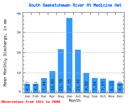
| Statistic | Jan | Feb | Mar | Apr | May | Jun | Jul | Aug | Sep | Oct | Nov | Dec | Annual |
|---|---|---|---|---|---|---|---|---|---|---|---|---|---|
| Mean | 3.41 | 3.40 | 5.55 | 8.06 | 16.25 | 27.73 | 15.98 | 7.41 | 5.48 | 5.27 | 4.56 | 3.61 | 106.69 |
| Standard Deviation | 1.14 | 1.13 | 2.21 | 4.14 | 8.15 | 14.87 | 10.26 | 4.89 | 4.51 | 3.21 | 1.71 | 1.19 | 41.22 |
| Min | 1.43 | 1.45 | 2.25 | 1.33 | 1.92 | 3.68 | 1.69 | 1.76 | 1.07 | 0.86 | 1.66 | 1.27 | 36.60 |
| Max | 9.35 | 6.45 | 12.82 | 25.69 | 48.43 | 75.37 | 50.81 | 24.83 | 28.86 | 19.04 | 12.09 | 7.17 | 232.94 |
| Coefficient of Variation | 0.33 | 0.33 | 0.40 | 0.51 | 0.50 | 0.54 | 0.64 | 0.66 | 0.82 | 0.61 | 0.38 | 0.33 | 0.39 |
 Return to R-Arctic Net Home Page