|
|
|||||||||||||||||
| Point ID: 170 | Downloads | Plots | Site Data | Code: 05AF032 |
|
|
|||||||||||||||||
| Download | |
|---|---|
| Site Descriptor Information | Site Time Series Data |
| Link to all available data | |
| View: | Time Series | All |
| Units: | mm |
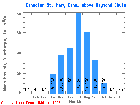
| Statistic | Jan | Feb | Mar | Apr | May | Jun | Jul | Aug | Sep | Oct | Nov | Dec | Annual |
|---|---|---|---|---|---|---|---|---|---|---|---|---|---|
| Mean | 19.03 | 38.30 | 44.45 | 79.70 | 60.85 | 33.00 | 10.65 | ||||||
| Standard Deviation | 26.54 | 20.08 | 3.18 | 3.68 | 8.41 | 27.15 | 4.88 | ||||||
| Min | 0.26 | 24.10 | 42.20 | 77.10 | 54.90 | 13.80 | 7.20 | ||||||
| Max | 37.80 | 52.50 | 46.70 | 82.30 | 66.80 | 52.20 | 14.10 | ||||||
| Coefficient of Variation | 1.40 | 0.52 | 0.07 | 0.05 | 0.14 | 0.82 | 0.46 |
 Return to R-Arctic Net Home Page