|
|
| Point ID: 170 | Downloads | Plots | Site Data | Code: 05AF032 |
|
| Download | |
|---|---|
| Site Descriptor Information | Site Time Series Data |
| Link to all available data | |
|
|
|
| View: | Statistics | All |
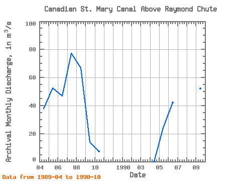
| Units: | mm |
| Year | Jan | Feb | Mar | Apr | May | Jun | Jul | Aug | Sep | Oct | Nov | Dec | Annual | 1989 | 37.80 | 52.50 | 46.70 | 77.10 | 66.80 | 13.80 | 7.20 | 1990 | 0.26 | 24.10 | 42.20 | 82.30 | 54.90 | 52.20 | 14.10 |
|---|
 Return to R-Arctic Net Home Page