|
|
|||||||||||||||||
| Point ID: 156 | Downloads | Plots | Site Data | Code: 05AF004 |
|
|
|||||||||||||||||
| Download | |
|---|---|
| Site Descriptor Information | Site Time Series Data |
| Link to all available data | |
| View: | Time Series | All |
| Units: | mm |
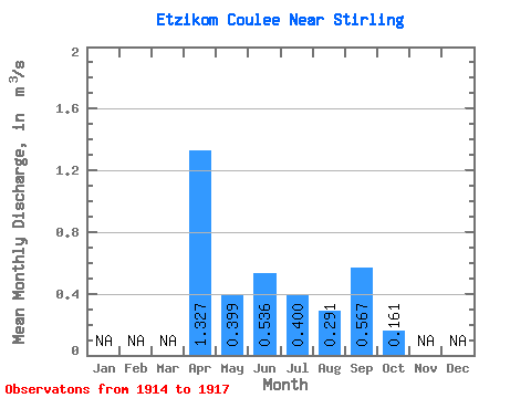
| Statistic | Jan | Feb | Mar | Apr | May | Jun | Jul | Aug | Sep | Oct | Nov | Dec | Annual |
|---|---|---|---|---|---|---|---|---|---|---|---|---|---|
| Mean | 1.33 | 0.40 | 0.54 | 0.40 | 0.29 | 0.57 | 0.16 | ||||||
| Standard Deviation | 1.77 | 0.40 | 0.35 | 0.42 | 0.20 | 0.79 | 0.27 | ||||||
| Min | 0.15 | 0.02 | 0.01 | 0.01 | 0.09 | 0.09 | 0.00 | ||||||
| Max | 3.36 | 0.95 | 0.76 | 0.79 | 0.50 | 1.48 | 0.47 | ||||||
| Coefficient of Variation | 1.33 | 1.00 | 0.66 | 1.06 | 0.69 | 1.40 | 1.67 |
 Return to R-Arctic Net Home Page