|
|
| Point ID: 156 | Downloads | Plots | Site Data | Code: 05AF004 |
|
| Download | |
|---|---|
| Site Descriptor Information | Site Time Series Data |
| Link to all available data | |
|
|
|
| View: | Statistics | All |
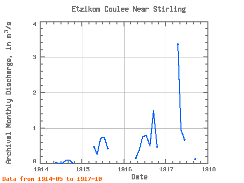
| Units: | mm |
| Year | Jan | Feb | Mar | Apr | May | Jun | Jul | Aug | Sep | Oct | Nov | Dec | Annual | 1914 | 0.02 | 0.01 | 0.01 | 0.09 | 0.09 | 0.01 | 1915 | 0.47 | 0.24 | 0.71 | 0.74 | 0.42 | 1916 | 0.15 | 0.39 | 0.76 | 0.79 | 0.50 | 1.48 | 0.47 | 1917 | 3.36 | 0.95 | 0.67 | 0.06 | 0.15 | 0.13 | 0.00 |
|---|
 Return to R-Arctic Net Home Page