|
|
|||||||||||||||||
| Point ID: 14 | Downloads | Plots | Site Data | Code: 05AA015 |
|
|
|||||||||||||||||
| Download | |
|---|---|
| Site Descriptor Information | Site Time Series Data |
| Link to all available data | |
| View: | Time Series | All |
| Units: | mm |
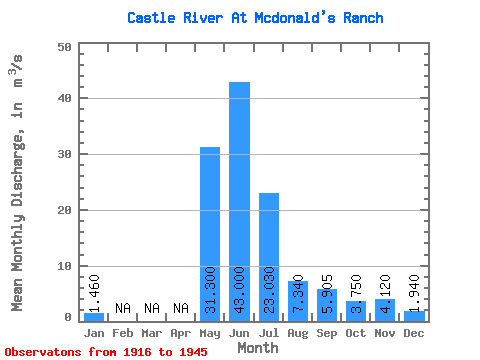
| Statistic | Jan | Feb | Mar | Apr | May | Jun | Jul | Aug | Sep | Oct | Nov | Dec | Annual |
|---|---|---|---|---|---|---|---|---|---|---|---|---|---|
| Mean | 1.46 | 31.30 | 43.00 | 23.03 | 7.34 | 5.91 | 3.75 | 4.12 | 1.94 | ||||
| Standard Deviation | 36.63 | 21.59 | 4.04 | 2.86 | 0.51 | 1.85 | |||||||
| Min | 1.46 | 31.30 | 17.10 | 7.76 | 4.48 | 3.88 | 3.39 | 2.81 | 1.94 | ||||
| Max | 1.46 | 31.30 | 68.90 | 38.30 | 10.20 | 7.93 | 4.11 | 5.43 | 1.94 | ||||
| Coefficient of Variation | 0.85 | 0.94 | 0.55 | 0.48 | 0.14 | 0.45 |
 Return to R-Arctic Net Home Page