|
|
|||||||||||||||||
| Point ID: 14 | Downloads | Plots | Site Data | Code: 05AA015 |
|
|
|||||||||||||||||
| Download | |
|---|---|
| Site Descriptor Information | Site Time Series Data |
| Link to all available data | |
| View: | Time Series | All |
| Units: | m3/s |
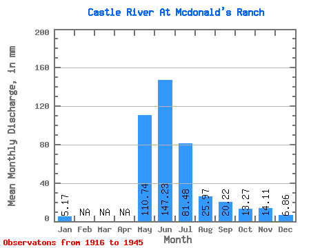
| Statistic | Jan | Feb | Mar | Apr | May | Jun | Jul | Aug | Sep | Oct | Nov | Dec | Annual |
|---|---|---|---|---|---|---|---|---|---|---|---|---|---|
| Mean | 5.17 | 110.73 | 147.23 | 81.47 | 25.97 | 20.22 | 13.27 | 14.11 | 6.86 | ||||
| Standard Deviation | 125.42 | 76.40 | 14.31 | 9.81 | 1.80 | 6.34 | |||||||
| Min | 5.17 | 110.73 | 58.55 | 27.45 | 15.85 | 13.29 | 11.99 | 9.62 | 6.86 | ||||
| Max | 5.17 | 110.73 | 235.92 | 135.49 | 36.08 | 27.15 | 14.54 | 18.59 | 6.86 | ||||
| Coefficient of Variation | 0.85 | 0.94 | 0.55 | 0.48 | 0.14 | 0.45 |
 Return to R-Arctic Net Home Page