|
|
|||||||||||||||||
| Point ID: 136 | Downloads | Plots | Site Data | Code: 05AE020 |
|
|
|||||||||||||||||
| Download | |
|---|---|
| Site Descriptor Information | Site Time Series Data |
| Link to all available data | |
| View: | Time Series | All |
| Units: | mm |
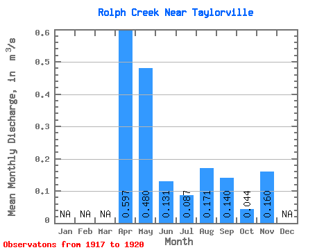
| Statistic | Jan | Feb | Mar | Apr | May | Jun | Jul | Aug | Sep | Oct | Nov | Dec | Annual |
|---|---|---|---|---|---|---|---|---|---|---|---|---|---|
| Mean | 0.60 | 0.48 | 0.13 | 0.09 | 0.17 | 0.14 | 0.04 | 0.16 | |||||
| Standard Deviation | 0.56 | 0.48 | 0.03 | 0.08 | 0.10 | 0.13 | 0.03 | ||||||
| Min | 0.20 | 0.16 | 0.09 | 0.03 | 0.06 | 0.02 | 0.01 | 0.16 | |||||
| Max | 0.99 | 1.03 | 0.16 | 0.18 | 0.28 | 0.30 | 0.09 | 0.16 | |||||
| Coefficient of Variation | 0.94 | 1.00 | 0.26 | 0.93 | 0.61 | 0.90 | 0.74 |
 Return to R-Arctic Net Home Page