|
|
| Point ID: 136 | Downloads | Plots | Site Data | Code: 05AE020 |
|
| Download | |
|---|---|
| Site Descriptor Information | Site Time Series Data |
| Link to all available data | |
|
|
|
| View: | Statistics | All |
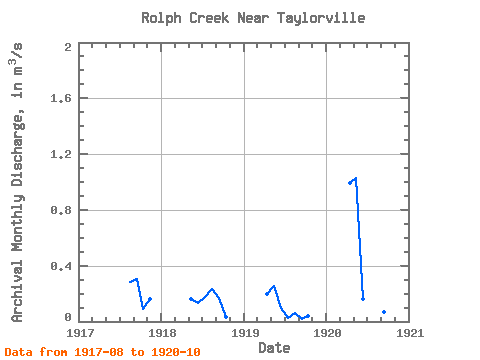
| Units: | mm |
| Year | Jan | Feb | Mar | Apr | May | Jun | Jul | Aug | Sep | Oct | Nov | Dec | Annual | 1917 | 0.28 | 0.30 | 0.09 | 0.16 | 1918 | 0.16 | 0.14 | 0.18 | 0.23 | 0.17 | 0.03 | 1919 | 0.20 | 0.25 | 0.09 | 0.03 | 0.06 | 0.02 | 0.04 | 1920 | 0.99 | 1.03 | 0.16 | 0.06 | 0.11 | 0.07 | 0.01 |
|---|
 Return to R-Arctic Net Home Page