|
|
|||||||||||||||||
| Point ID: 117 | Downloads | Plots | Site Data | Code: 05AD901 |
|
|
|||||||||||||||||
| Download | |
|---|---|
| Site Descriptor Information | Site Time Series Data |
| Link to all available data | |
| View: | Time Series | All |
| Units: | mm |
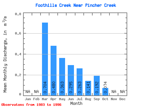
| Statistic | Jan | Feb | Mar | Apr | May | Jun | Jul | Aug | Sep | Oct | Nov | Dec | Annual |
|---|---|---|---|---|---|---|---|---|---|---|---|---|---|
| Mean | 0.70 | 0.48 | 0.36 | 0.29 | 0.26 | 0.14 | 0.19 | 0.07 | |||||
| Standard Deviation | 0.95 | 0.58 | 0.52 | 0.52 | 0.66 | 0.43 | 0.65 | 0.14 | |||||
| Min | 0.03 | 0.00 | 0.00 | 0.00 | 0.00 | 0.00 | 0.00 | 0.00 | |||||
| Max | 1.38 | 1.76 | 1.58 | 1.80 | 2.30 | 1.44 | 2.27 | 0.47 | |||||
| Coefficient of Variation | 1.36 | 1.21 | 1.42 | 1.77 | 2.50 | 3.06 | 3.40 | 1.94 |
 Return to R-Arctic Net Home Page