|
|
|||||||||||||||||
| Point ID: 117 | Downloads | Plots | Site Data | Code: 05AD901 |
|
|
|||||||||||||||||
| Download | |
|---|---|
| Site Descriptor Information | Site Time Series Data |
| Link to all available data | |
| View: | Time Series | All |
| Units: | m3/s |
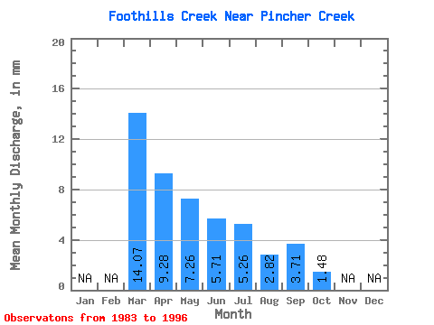
| Statistic | Jan | Feb | Mar | Apr | May | Jun | Jul | Aug | Sep | Oct | Nov | Dec | Annual |
|---|---|---|---|---|---|---|---|---|---|---|---|---|---|
| Mean | 14.08 | 9.28 | 7.25 | 5.71 | 5.25 | 2.81 | 3.72 | 1.48 | |||||
| Standard Deviation | 19.09 | 11.19 | 10.30 | 10.11 | 13.12 | 8.62 | 12.66 | 2.87 | |||||
| Min | 0.58 | 0.04 | 0.00 | 0.02 | 0.00 | 0.00 | 0.00 | 0.00 | |||||
| Max | 27.58 | 34.04 | 31.58 | 34.82 | 45.97 | 28.78 | 43.91 | 9.39 | |||||
| Coefficient of Variation | 1.36 | 1.21 | 1.42 | 1.77 | 2.50 | 3.06 | 3.40 | 1.94 |
 Return to R-Arctic Net Home Page