|
|
|||||||||||||||||
| Point ID: 9490 | Downloads | Plots | Site Data | Code: 15296000 |
|
|
|||||||||||||||||
| Download | |
|---|---|
| Site Descriptor Information | Site Time Series Data |
| Link to all available data | |
| View: | Time Series | All |
| Units: | m3/s |
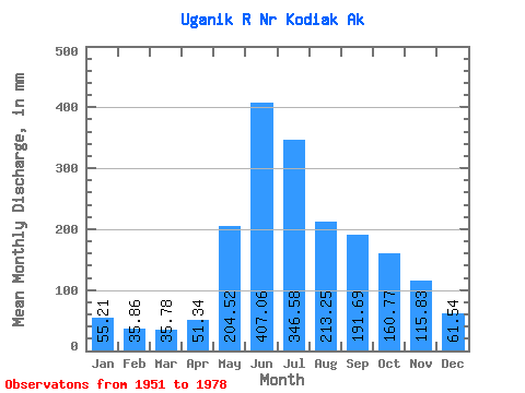
| Statistic | Jan | Feb | Mar | Apr | May | Jun | Jul | Aug | Sep | Oct | Nov | Dec | Annual |
|---|---|---|---|---|---|---|---|---|---|---|---|---|---|
| Mean | 55.20 | 36.17 | 35.78 | 51.34 | 204.49 | 407.06 | 346.53 | 213.22 | 191.69 | 160.75 | 115.83 | 61.52 | 1878.54 |
| Standard Deviation | 56.69 | 26.62 | 27.57 | 18.40 | 65.30 | 100.91 | 115.63 | 76.73 | 91.67 | 93.28 | 88.39 | 38.83 | 280.28 |
| Min | 12.62 | 10.40 | 6.22 | 15.95 | 112.63 | 238.23 | 108.85 | 91.38 | 58.50 | 38.60 | 23.04 | 19.42 | 1473.96 |
| Max | 263.74 | 113.35 | 150.22 | 88.33 | 357.80 | 664.71 | 614.08 | 453.86 | 446.54 | 501.26 | 317.36 | 147.57 | 2593.82 |
| Coefficient of Variation | 1.03 | 0.74 | 0.77 | 0.36 | 0.32 | 0.25 | 0.33 | 0.36 | 0.48 | 0.58 | 0.76 | 0.63 | 0.15 |
 Return to R-Arctic Net Home Page