|
|
|||||||||||||||||
| Point ID: 9490 | Downloads | Plots | Site Data | Code: 15296000 |
|
|
|||||||||||||||||
| Download | |
|---|---|
| Site Descriptor Information | Site Time Series Data |
| Link to all available data | |
|
|
| View: | Statistics | Time Series |
| Units: | m3/s |
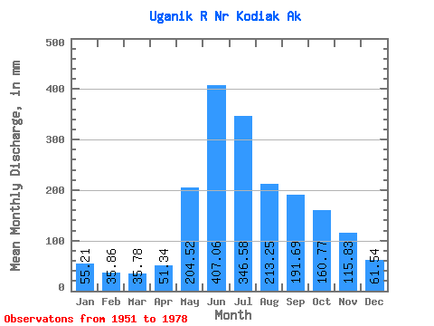
| Statistic | Jan | Feb | Mar | Apr | May | Jun | Jul | Aug | Sep | Oct | Nov | Dec | Annual |
|---|---|---|---|---|---|---|---|---|---|---|---|---|---|
| Mean | 55.20 | 36.17 | 35.78 | 51.34 | 204.49 | 407.06 | 346.53 | 213.22 | 191.69 | 160.75 | 115.83 | 61.52 | 1878.54 |
| Standard Deviation | 56.69 | 26.62 | 27.57 | 18.40 | 65.30 | 100.91 | 115.63 | 76.73 | 91.67 | 93.28 | 88.39 | 38.83 | 280.28 |
| Min | 12.62 | 10.40 | 6.22 | 15.95 | 112.63 | 238.23 | 108.85 | 91.38 | 58.50 | 38.60 | 23.04 | 19.42 | 1473.96 |
| Max | 263.74 | 113.35 | 150.22 | 88.33 | 357.80 | 664.71 | 614.08 | 453.86 | 446.54 | 501.26 | 317.36 | 147.57 | 2593.82 |
| Coefficient of Variation | 1.03 | 0.74 | 0.77 | 0.36 | 0.32 | 0.25 | 0.33 | 0.36 | 0.48 | 0.58 | 0.76 | 0.63 | 0.15 |
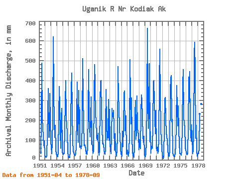
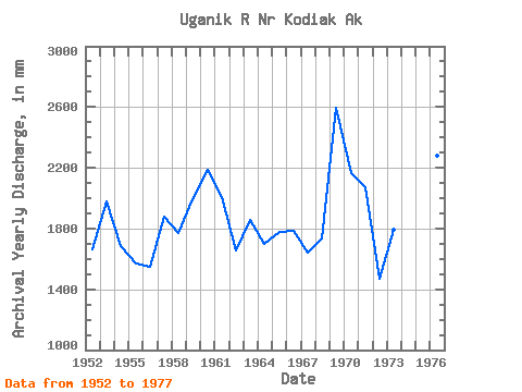
| Year | Jan | Feb | Mar | Apr | May | Jun | Jul | Aug | Sep | Oct | Nov | Dec | Annual | 1951 | 30.87 | 206.44 | 488.39 | 219.83 | 163.17 | 121.90 | 73.33 | 96.33 | 25.30 | 1952 | 17.95 | 12.80 | 14.88 | 19.79 | 127.84 | 238.23 | 371.79 | 118.62 | 114.67 | 345.74 | 195.67 | 96.91 | 1664.61 | 1953 | 62.65 | 35.86 | 32.09 | 88.33 | 217.31 | 621.40 | 355.57 | 195.63 | 115.23 | 179.63 | 46.63 | 35.11 | 1981.68 | 1954 | 23.10 | 17.34 | 18.09 | 36.58 | 226.85 | 370.98 | 276.00 | 139.55 | 58.50 | 222.14 | 260.20 | 42.90 | 1687.21 | 1955 | 28.56 | 23.86 | 34.16 | 30.25 | 158.27 | 291.55 | 412.85 | 220.10 | 179.97 | 137.92 | 39.49 | 22.57 | 1571.14 | 1956 | 12.62 | 10.84 | 12.62 | 41.68 | 222.59 | 349.52 | 453.09 | 249.34 | 97.12 | 44.69 | 35.18 | 28.45 | 1547.92 | 1957 | 20.89 | 19.07 | 32.80 | 64.52 | 232.37 | 391.56 | 166.36 | 91.38 | 350.83 | 188.19 | 252.64 | 65.22 | 1878.57 | 1958 | 74.98 | 64.73 | 58.10 | 79.83 | 191.97 | 510.51 | 315.33 | 199.11 | 71.87 | 80.01 | 69.15 | 55.34 | 1769.22 | 1959 | 33.02 | 28.35 | 29.79 | 65.00 | 256.44 | 455.76 | 236.65 | 162.15 | 115.82 | 214.97 | 317.36 | 82.31 | 1995.59 | 1960 | 97.63 | 50.52 | 35.90 | 42.80 | 332.32 | 480.02 | 391.98 | 224.45 | 208.10 | 116.08 | 100.64 | 116.79 | 2189.80 | 1961 | 138.28 | 42.51 | 25.90 | 49.27 | 299.40 | 398.09 | 414.15 | 238.49 | 170.49 | 85.39 | 83.10 | 74.01 | 2009.79 | 1962 | 54.74 | 30.36 | 28.56 | 57.59 | 168.07 | 354.52 | 187.80 | 105.83 | 143.61 | 115.73 | 305.94 | 102.85 | 1656.91 | 1963 | 263.74 | 73.98 | 51.26 | 31.07 | 129.34 | 258.83 | 224.82 | 225.22 | 249.54 | 172.39 | 49.36 | 136.67 | 1859.04 | 1964 | 53.95 | 27.45 | 20.69 | 49.36 | 119.87 | 469.43 | 311.51 | 293.13 | 142.40 | 131.23 | 53.03 | 29.77 | 1697.22 | 1965 | 30.52 | 18.63 | 150.22 | 65.72 | 168.96 | 332.98 | 360.08 | 152.55 | 214.80 | 229.63 | 29.49 | 31.30 | 1775.62 | 1966 | 50.22 | 26.52 | 18.26 | 47.34 | 120.71 | 504.37 | 333.51 | 188.93 | 311.40 | 120.08 | 37.20 | 26.34 | 1784.78 | 1967 | 20.27 | 13.12 | 15.82 | 59.46 | 238.54 | 299.98 | 108.85 | 137.84 | 322.20 | 155.63 | 148.97 | 126.69 | 1646.17 | 1968 | 53.75 | 95.94 | 72.25 | 56.90 | 240.60 | 326.72 | 310.34 | 221.23 | 121.21 | 91.30 | 118.64 | 28.91 | 1736.15 | 1969 | 17.70 | 16.19 | 32.78 | 87.08 | 313.88 | 664.71 | 314.57 | 163.44 | 252.98 | 501.26 | 91.07 | 147.57 | 2593.82 | 1970 | 35.66 | 64.02 | 64.49 | 59.11 | 185.16 | 393.86 | 412.23 | 303.17 | 202.39 | 136.48 | 250.12 | 66.48 | 2169.86 | 1971 | 47.22 | 59.25 | 35.71 | 46.07 | 112.63 | 392.79 | 577.53 | 311.37 | 185.93 | 158.00 | 103.05 | 50.14 | 2071.82 | 1972 | 29.98 | 10.40 | 6.22 | 15.95 | 173.41 | 305.49 | 324.21 | 211.12 | 135.84 | 119.27 | 97.65 | 51.89 | 1473.96 | 1973 | 22.61 | 18.47 | 20.62 | 49.07 | 357.80 | 411.60 | 438.18 | 197.71 | 204.88 | 38.60 | 23.04 | 19.42 | 1793.92 | 1974 | 17.81 | 14.79 | 38.62 | 74.56 | 183.88 | 374.59 | 265.19 | 177.20 | 272.46 | 151.56 | 87.85 | 32.17 | 1688.18 | 1975 | 32.32 | 27.26 | 24.19 | 46.77 | 181.03 | 383.57 | 471.66 | 232.91 | 177.03 | 172.74 | 61.09 | 48.22 | 1849.86 | 1976 | 43.15 | 26.32 | 27.87 | 33.17 | 178.47 | 394.02 | 432.88 | 302.00 | 446.54 | 177.70 | 127.39 | 97.57 | 2281.24 | 1977 | 181.56 | 113.35 | 31.39 | 49.81 | 140.91 | 536.49 | 614.08 | 453.86 | 107.89 | 180.59 | 47.13 | 20.27 | 2467.95 | 1978 | 25.53 | 34.62 | 32.71 | 59.45 | 240.72 | 397.78 | 401.79 | 290.59 | 271.83 |
|---|
 Return to R-Arctic Net Home Page