|
|
|||||||||||||||||
| Point ID: 9359 | Downloads | Plots | Site Data | Code: 15254000 |
|
|
|||||||||||||||||
| Download | |
|---|---|
| Site Descriptor Information | Site Time Series Data |
| Link to all available data | |
| View: | Time Series | All |
| Units: | m3/s |
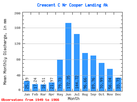
| Statistic | Jan | Feb | Mar | Apr | May | Jun | Jul | Aug | Sep | Oct | Nov | Dec | Annual |
|---|---|---|---|---|---|---|---|---|---|---|---|---|---|
| Mean | 25.18 | 17.38 | 16.50 | 21.98 | 79.72 | 172.35 | 144.71 | 96.65 | 89.77 | 70.97 | 56.04 | 33.74 | 815.88 |
| Standard Deviation | 12.83 | 5.83 | 3.98 | 10.43 | 39.86 | 61.55 | 45.14 | 26.52 | 33.98 | 29.62 | 35.89 | 14.47 | 180.04 |
| Min | 11.53 | 10.11 | 11.04 | 9.38 | 30.69 | 107.31 | 80.44 | 55.24 | 52.03 | 37.48 | 25.04 | 17.02 | 589.64 |
| Max | 65.67 | 34.14 | 27.12 | 53.20 | 178.24 | 327.86 | 245.19 | 134.10 | 169.85 | 144.32 | 149.98 | 65.61 | 1151.68 |
| Coefficient of Variation | 0.51 | 0.34 | 0.24 | 0.47 | 0.50 | 0.36 | 0.31 | 0.27 | 0.38 | 0.42 | 0.64 | 0.43 | 0.22 |
 Return to R-Arctic Net Home Page