|
|
|||||||||||||||||
| Point ID: 9359 | Downloads | Plots | Site Data | Code: 15254000 |
|
|
|||||||||||||||||
| Download | |
|---|---|
| Site Descriptor Information | Site Time Series Data |
| Link to all available data | |
|
|
| View: | Statistics | Time Series |
| Units: | m3/s |
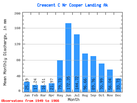
| Statistic | Jan | Feb | Mar | Apr | May | Jun | Jul | Aug | Sep | Oct | Nov | Dec | Annual |
|---|---|---|---|---|---|---|---|---|---|---|---|---|---|
| Mean | 25.18 | 17.38 | 16.50 | 21.98 | 79.72 | 172.35 | 144.71 | 96.65 | 89.77 | 70.97 | 56.04 | 33.74 | 815.88 |
| Standard Deviation | 12.83 | 5.83 | 3.98 | 10.43 | 39.86 | 61.55 | 45.14 | 26.52 | 33.98 | 29.62 | 35.89 | 14.47 | 180.04 |
| Min | 11.53 | 10.11 | 11.04 | 9.38 | 30.69 | 107.31 | 80.44 | 55.24 | 52.03 | 37.48 | 25.04 | 17.02 | 589.64 |
| Max | 65.67 | 34.14 | 27.12 | 53.20 | 178.24 | 327.86 | 245.19 | 134.10 | 169.85 | 144.32 | 149.98 | 65.61 | 1151.68 |
| Coefficient of Variation | 0.51 | 0.34 | 0.24 | 0.47 | 0.50 | 0.36 | 0.31 | 0.27 | 0.38 | 0.42 | 0.64 | 0.43 | 0.22 |
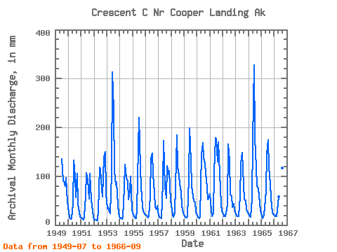
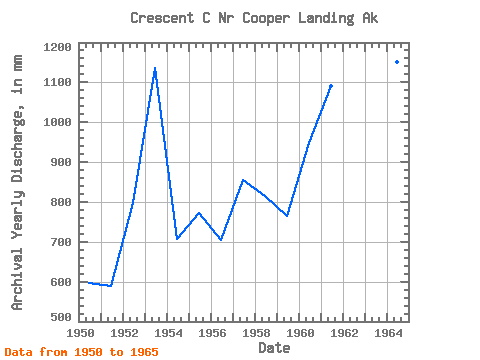
| Year | Jan | Feb | Mar | Apr | May | Jun | Jul | Aug | Sep | Oct | Nov | Dec | Annual | 1949 | 140.39 | 94.06 | 89.94 | 82.89 | 97.33 | 50.30 | 1950 | 27.63 | 14.13 | 13.26 | 13.62 | 43.17 | 132.19 | 102.06 | 58.64 | 104.75 | 44.79 | 25.04 | 17.08 | 596.00 | 1951 | 15.21 | 12.23 | 11.09 | 17.87 | 61.17 | 107.31 | 95.12 | 55.24 | 105.13 | 53.55 | 39.34 | 17.02 | 589.64 | 1952 | 11.53 | 10.11 | 11.04 | 9.38 | 30.69 | 118.15 | 116.55 | 75.68 | 57.81 | 144.32 | 149.98 | 65.61 | 798.41 | 1953 | 34.72 | 34.14 | 27.12 | 23.81 | 107.02 | 313.64 | 245.19 | 112.60 | 83.08 | 91.83 | 41.18 | 24.01 | 1136.24 | 1954 | 13.86 | 14.29 | 12.00 | 15.81 | 79.88 | 123.31 | 98.61 | 92.43 | 52.27 | 73.71 | 99.44 | 32.66 | 706.42 | 1955 | 25.87 | 16.82 | 15.14 | 12.95 | 33.43 | 157.44 | 227.32 | 120.34 | 77.69 | 39.53 | 27.39 | 23.09 | 773.69 | 1956 | 22.18 | 18.52 | 15.69 | 17.87 | 59.34 | 136.72 | 152.07 | 107.02 | 67.34 | 37.51 | 32.94 | 41.16 | 705.75 | 1957 | 20.23 | 15.16 | 15.88 | 13.88 | 89.18 | 172.81 | 80.44 | 57.71 | 120.87 | 107.50 | 111.24 | 50.77 | 855.45 | 1958 | 42.50 | 19.35 | 17.22 | 24.71 | 82.59 | 183.53 | 122.42 | 104.52 | 84.43 | 70.35 | 39.75 | 25.96 | 815.38 | 1959 | 18.20 | 15.16 | 15.54 | 19.97 | 97.31 | 198.86 | 135.86 | 82.11 | 59.32 | 50.53 | 46.01 | 27.59 | 764.74 | 1960 | 19.36 | 15.16 | 14.78 | 17.43 | 148.14 | 167.77 | 143.13 | 129.40 | 106.18 | 78.96 | 52.95 | 58.90 | 947.77 | 1961 | 65.67 | 28.59 | 17.98 | 24.02 | 111.31 | 178.09 | 183.15 | 134.10 | 169.85 | 108.78 | 43.96 | 28.96 | 1091.15 | 1962 | 24.44 | 17.28 | 18.46 | 25.49 | 42.43 | 165.51 | 137.00 | 64.21 | 59.24 | 37.48 | 43.80 | 31.41 | 666.05 | 1963 | 23.18 | 17.68 | 18.18 | 17.94 | 59.80 | 125.43 | 153.11 | 85.06 | 52.03 | 52.05 | 30.28 | 25.87 | 657.82 | 1964 | 23.09 | 16.82 | 16.64 | 53.20 | 178.24 | 327.86 | 183.74 | 122.40 | 79.98 | 76.40 | 45.74 | 30.13 | 1151.68 | 1965 | 18.23 | 13.22 | 22.08 | 35.52 | 71.12 | 146.77 | 180.35 | 122.94 | 85.59 | 56.23 | 26.24 | 23.09 | 797.88 | 1966 | 22.18 | 16.82 | 18.38 | 30.13 | 60.34 | 174.54 | 108.20 | 121.18 | 160.32 |
|---|
 Return to R-Arctic Net Home Page