|
|
|||||||||||||||||
| Point ID: 9304 | Downloads | Plots | Site Data | Code: 15085600 |
|
|
|||||||||||||||||
| Download | |
|---|---|
| Site Descriptor Information | Site Time Series Data |
| Link to all available data | |
| View: | Time Series | All |
| Units: | m3/s |
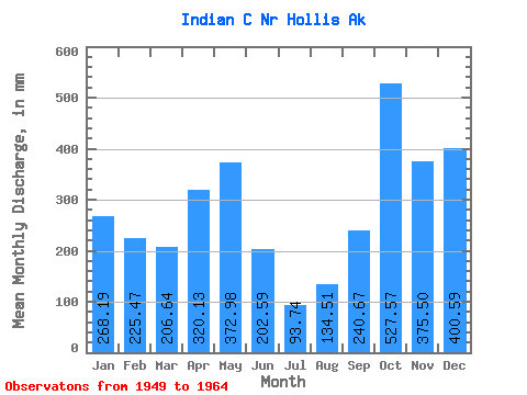
| Statistic | Jan | Feb | Mar | Apr | May | Jun | Jul | Aug | Sep | Oct | Nov | Dec | Annual |
|---|---|---|---|---|---|---|---|---|---|---|---|---|---|
| Mean | 268.17 | 227.41 | 206.62 | 320.18 | 372.93 | 202.59 | 93.75 | 134.45 | 240.69 | 527.50 | 375.52 | 400.47 | 3320.49 |
| Standard Deviation | 200.78 | 107.87 | 110.96 | 101.27 | 154.12 | 115.61 | 53.84 | 69.33 | 83.91 | 216.60 | 129.32 | 160.52 | 621.54 |
| Min | 13.20 | 15.91 | 45.61 | 107.84 | 107.40 | 10.91 | 30.66 | 12.12 | 88.83 | 196.60 | 159.99 | 94.95 | 2200.61 |
| Max | 781.82 | 456.30 | 364.36 | 515.82 | 680.01 | 510.78 | 227.63 | 255.03 | 359.13 | 950.91 | 638.69 | 660.48 | 4233.70 |
| Coefficient of Variation | 0.75 | 0.47 | 0.54 | 0.32 | 0.41 | 0.57 | 0.57 | 0.52 | 0.35 | 0.41 | 0.34 | 0.40 | 0.19 |
 Return to R-Arctic Net Home Page