|
|
|||||||||||||||||
| Point ID: 9304 | Downloads | Plots | Site Data | Code: 15085600 |
|
|
|||||||||||||||||
| Download | |
|---|---|
| Site Descriptor Information | Site Time Series Data |
| Link to all available data | |
|
|
| View: | Statistics | Time Series |
| Units: | m3/s |
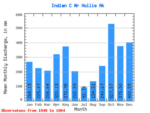
| Statistic | Jan | Feb | Mar | Apr | May | Jun | Jul | Aug | Sep | Oct | Nov | Dec | Annual |
|---|---|---|---|---|---|---|---|---|---|---|---|---|---|
| Mean | 268.17 | 227.41 | 206.62 | 320.18 | 372.93 | 202.59 | 93.75 | 134.45 | 240.69 | 527.50 | 375.52 | 400.47 | 3320.49 |
| Standard Deviation | 200.78 | 107.87 | 110.96 | 101.27 | 154.12 | 115.61 | 53.84 | 69.33 | 83.91 | 216.60 | 129.32 | 160.52 | 621.54 |
| Min | 13.20 | 15.91 | 45.61 | 107.84 | 107.40 | 10.91 | 30.66 | 12.12 | 88.83 | 196.60 | 159.99 | 94.95 | 2200.61 |
| Max | 781.82 | 456.30 | 364.36 | 515.82 | 680.01 | 510.78 | 227.63 | 255.03 | 359.13 | 950.91 | 638.69 | 660.48 | 4233.70 |
| Coefficient of Variation | 0.75 | 0.47 | 0.54 | 0.32 | 0.41 | 0.57 | 0.57 | 0.52 | 0.35 | 0.41 | 0.34 | 0.40 | 0.19 |
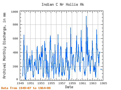
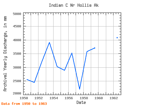
| Year | Jan | Feb | Mar | Apr | May | Jun | Jul | Aug | Sep | Oct | Nov | Dec | Annual | 1949 | 63.90 | 136.96 | 359.13 | 671.85 | 354.64 | 102.24 | 1950 | 13.20 | 15.91 | 58.16 | 233.82 | 512.63 | 266.77 | 128.97 | 184.23 | 281.37 | 326.08 | 187.91 | 360.82 | 2556.89 | 1951 | 153.75 | 131.45 | 289.10 | 300.89 | 442.57 | 151.63 | 55.20 | 45.03 | 88.83 | 266.99 | 213.65 | 315.76 | 2448.03 | 1952 | 225.31 | 158.83 | 149.78 | 425.04 | 504.49 | 239.18 | 97.72 | 98.82 | 308.93 | 388.19 | 290.90 | 336.77 | 3222.62 | 1953 | 165.53 | 456.30 | 351.81 | 343.27 | 518.53 | 70.55 | 42.52 | 132.35 | 335.49 | 578.08 | 424.72 | 480.04 | 3911.28 | 1954 | 102.36 | 346.44 | 45.61 | 107.84 | 288.40 | 175.77 | 77.64 | 12.12 | 152.50 | 541.65 | 638.69 | 520.78 | 3024.07 | 1955 | 275.00 | 218.73 | 140.66 | 227.93 | 403.94 | 306.14 | 30.66 | 255.03 | 241.87 | 532.59 | 159.99 | 94.95 | 2887.13 | 1956 | 149.45 | 170.54 | 190.23 | 347.78 | 680.01 | 172.98 | 57.44 | 247.78 | 122.60 | 449.98 | 490.72 | 453.51 | 3523.05 | 1957 | 76.40 | 105.86 | 66.19 | 322.57 | 243.22 | 122.16 | 91.03 | 77.78 | 173.45 | 196.60 | 451.43 | 268.23 | 2200.61 | 1958 | 561.13 | 250.65 | 151.39 | 283.83 | 258.67 | 10.91 | 34.88 | 202.24 | 181.99 | 779.36 | 382.22 | 490.31 | 3575.23 | 1959 | 160.94 | 246.32 | 364.36 | 348.10 | 387.53 | 159.50 | 153.04 | 122.42 | 233.50 | 378.64 | 497.46 | 660.48 | 3709.68 | 1960 | 287.86 | 248.60 | 330.22 | 515.82 | 395.15 | 220.62 | 171.60 | 129.51 | 292.51 | 744.27 | 408.72 | 494.18 | 4233.70 | 1961 | 297.62 | 266.78 | 316.61 | 330.50 | 107.40 | 135.32 | 68.83 | 127.06 | 190.84 | 950.91 | 393.60 | 375.92 | 3557.39 | 1962 | 781.82 | 195.03 | 297.08 | 437.16 | 304.49 | 237.46 | 100.89 | 168.49 | 338.76 | 357.93 | 293.04 | 588.60 | 4088.53 | 1963 | 437.42 | 248.83 | 133.26 | 206.14 | 129.08 | 259.15 | 97.96 | 45.88 | 331.19 | 749.42 | 445.11 | 464.46 | 3548.58 | 1964 | 334.75 | 350.80 | 214.91 | 371.93 | 417.90 | 510.78 | 227.63 | 165.52 | 217.99 |
|---|
 Return to R-Arctic Net Home Page