|
|
|||||||||||||||||
| Point ID: 9284 | Downloads | Plots | Site Data | Code: 15018000 |
|
|
|||||||||||||||||
| Download | |
|---|---|
| Site Descriptor Information | Site Time Series Data |
| Link to all available data | |
| View: | Time Series | All |
| Units: | m3/s |
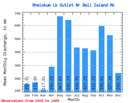
| Statistic | Jan | Feb | Mar | Apr | May | Jun | Jul | Aug | Sep | Oct | Nov | Dec | Annual |
|---|---|---|---|---|---|---|---|---|---|---|---|---|---|
| Mean | 158.89 | 173.30 | 117.81 | 290.23 | 667.73 | 640.22 | 433.87 | 427.16 | 412.19 | 595.75 | 527.35 | 243.67 | 4843.99 |
| Standard Deviation | 111.99 | 107.39 | 63.13 | 125.09 | 147.51 | 98.38 | 155.54 | 175.84 | 171.34 | 195.62 | 342.93 | 118.47 | 592.40 |
| Min | 39.05 | 22.23 | 33.79 | 172.24 | 459.64 | 422.88 | 114.81 | 241.42 | 183.18 | 366.03 | 220.92 | 106.81 | 4124.41 |
| Max | 349.43 | 341.75 | 235.05 | 534.68 | 882.81 | 770.13 | 609.05 | 771.04 | 666.75 | 933.00 | 1417.26 | 495.60 | 5907.36 |
| Coefficient of Variation | 0.70 | 0.62 | 0.54 | 0.43 | 0.22 | 0.15 | 0.36 | 0.41 | 0.42 | 0.33 | 0.65 | 0.49 | 0.12 |
 Return to R-Arctic Net Home Page