|
|
|||||||||||||||||
| Point ID: 9284 | Downloads | Plots | Site Data | Code: 15018000 |
|
|
|||||||||||||||||
| Download | |
|---|---|
| Site Descriptor Information | Site Time Series Data |
| Link to all available data | |
|
|
| View: | Statistics | Time Series |
| Units: | m3/s |
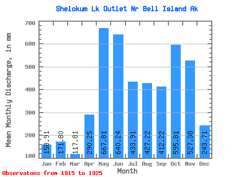
| Statistic | Jan | Feb | Mar | Apr | May | Jun | Jul | Aug | Sep | Oct | Nov | Dec | Annual |
|---|---|---|---|---|---|---|---|---|---|---|---|---|---|
| Mean | 158.89 | 173.30 | 117.81 | 290.23 | 667.73 | 640.22 | 433.87 | 427.16 | 412.19 | 595.75 | 527.35 | 243.67 | 4843.99 |
| Standard Deviation | 111.99 | 107.39 | 63.13 | 125.09 | 147.51 | 98.38 | 155.54 | 175.84 | 171.34 | 195.62 | 342.93 | 118.47 | 592.40 |
| Min | 39.05 | 22.23 | 33.79 | 172.24 | 459.64 | 422.88 | 114.81 | 241.42 | 183.18 | 366.03 | 220.92 | 106.81 | 4124.41 |
| Max | 349.43 | 341.75 | 235.05 | 534.68 | 882.81 | 770.13 | 609.05 | 771.04 | 666.75 | 933.00 | 1417.26 | 495.60 | 5907.36 |
| Coefficient of Variation | 0.70 | 0.62 | 0.54 | 0.43 | 0.22 | 0.15 | 0.36 | 0.41 | 0.42 | 0.33 | 0.65 | 0.49 | 0.12 |
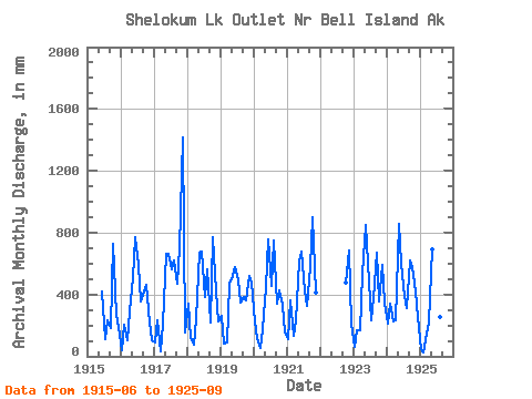
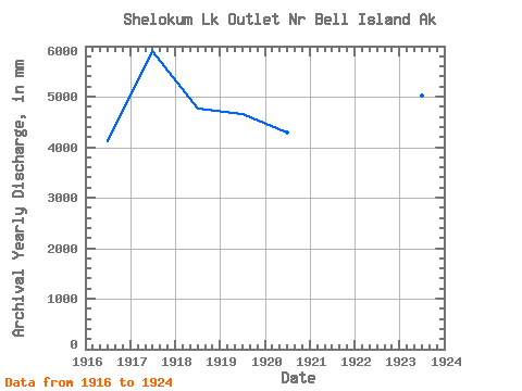
| Year | Jan | Feb | Mar | Apr | May | Jun | Jul | Aug | Sep | Oct | Nov | Dec | Annual | 1915 | 422.88 | 114.81 | 241.42 | 183.18 | 753.60 | 265.73 | 198.42 | 1916 | 39.05 | 192.19 | 104.33 | 291.59 | 524.37 | 770.13 | 609.05 | 364.51 | 422.34 | 479.07 | 220.92 | 106.81 | 4124.41 | 1917 | 93.86 | 222.34 | 33.79 | 214.37 | 681.98 | 662.99 | 581.80 | 642.08 | 470.49 | 721.46 | 1417.26 | 159.31 | 5907.36 | 1918 | 349.43 | 114.17 | 78.85 | 239.81 | 694.51 | 677.29 | 394.28 | 580.01 | 222.07 | 797.20 | 420.16 | 234.03 | 4777.46 | 1919 | 271.44 | 76.97 | 89.68 | 469.51 | 539.75 | 579.97 | 514.39 | 362.69 | 383.52 | 375.41 | 517.78 | 495.60 | 4663.81 | 1920 | 233.78 | 111.17 | 56.31 | 172.24 | 459.64 | 755.16 | 470.64 | 771.04 | 339.98 | 440.08 | 329.81 | 160.94 | 4286.39 | 1921 | 113.47 | 341.75 | 135.63 | 235.58 | 633.83 | 680.55 | 437.76 | 339.44 | 579.73 | 933.00 | 409.56 | 1922 | 494.87 | 681.40 | 217.74 | 1923 | 63.83 | 159.06 | 176.45 | 534.68 | 875.19 | 606.97 | 243.87 | 388.55 | 666.75 | 366.03 | 591.96 | 357.42 | 5034.05 | 1924 | 218.22 | 319.82 | 235.05 | 234.54 | 882.81 | 601.35 | 407.33 | 319.10 | 617.70 | 596.83 | 418.94 | 262.80 | 5114.47 | 1925 | 46.93 | 22.23 | 150.17 | 219.71 | 717.50 | 644.88 | 564.77 | 262.78 | 236.18 |
|---|
 Return to R-Arctic Net Home Page