|
|
|||||||||||||||||
| Point ID: 9244 | Downloads | Plots | Site Data | Code: 15044000 |
|
|
|||||||||||||||||
| Download | |
|---|---|
| Site Descriptor Information | Site Time Series Data |
| Link to all available data | |
| View: | Time Series | All |
| Units: | m3/s |
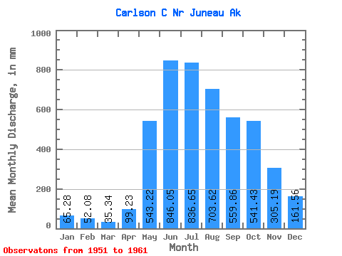
| Statistic | Jan | Feb | Mar | Apr | May | Jun | Jul | Aug | Sep | Oct | Nov | Dec | Annual |
|---|---|---|---|---|---|---|---|---|---|---|---|---|---|
| Mean | 65.28 | 52.53 | 35.32 | 99.22 | 543.12 | 846.05 | 836.53 | 703.53 | 559.87 | 541.35 | 305.18 | 161.53 | 4679.53 |
| Standard Deviation | 32.78 | 56.65 | 14.97 | 43.80 | 127.42 | 115.20 | 225.34 | 295.65 | 159.12 | 216.29 | 140.66 | 104.88 | 389.52 |
| Min | 20.48 | 17.57 | 15.67 | 35.01 | 329.32 | 654.04 | 625.09 | 341.15 | 329.02 | 319.10 | 135.32 | 35.43 | 4257.37 |
| Max | 127.13 | 207.22 | 62.88 | 172.20 | 701.31 | 1070.70 | 1354.92 | 1326.18 | 845.14 | 921.24 | 521.75 | 356.59 | 5361.69 |
| Coefficient of Variation | 0.50 | 1.08 | 0.42 | 0.44 | 0.23 | 0.14 | 0.27 | 0.42 | 0.28 | 0.40 | 0.46 | 0.65 | 0.08 |
 Return to R-Arctic Net Home Page