|
|
|||||||||||||||||
| Point ID: 9244 | Downloads | Plots | Site Data | Code: 15044000 |
|
|
|||||||||||||||||
| Download | |
|---|---|
| Site Descriptor Information | Site Time Series Data |
| Link to all available data | |
|
|
| View: | Statistics | Time Series |
| Units: | m3/s |
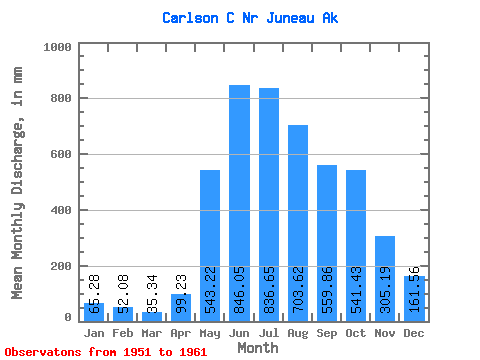
| Statistic | Jan | Feb | Mar | Apr | May | Jun | Jul | Aug | Sep | Oct | Nov | Dec | Annual |
|---|---|---|---|---|---|---|---|---|---|---|---|---|---|
| Mean | 65.28 | 52.53 | 35.32 | 99.22 | 543.12 | 846.05 | 836.53 | 703.53 | 559.87 | 541.35 | 305.18 | 161.53 | 4679.53 |
| Standard Deviation | 32.78 | 56.65 | 14.97 | 43.80 | 127.42 | 115.20 | 225.34 | 295.65 | 159.12 | 216.29 | 140.66 | 104.88 | 389.52 |
| Min | 20.48 | 17.57 | 15.67 | 35.01 | 329.32 | 654.04 | 625.09 | 341.15 | 329.02 | 319.10 | 135.32 | 35.43 | 4257.37 |
| Max | 127.13 | 207.22 | 62.88 | 172.20 | 701.31 | 1070.70 | 1354.92 | 1326.18 | 845.14 | 921.24 | 521.75 | 356.59 | 5361.69 |
| Coefficient of Variation | 0.50 | 1.08 | 0.42 | 0.44 | 0.23 | 0.14 | 0.27 | 0.42 | 0.28 | 0.40 | 0.46 | 0.65 | 0.08 |
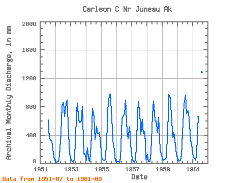
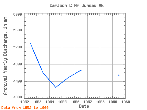
| Year | Jan | Feb | Mar | Apr | May | Jun | Jul | Aug | Sep | Oct | Nov | Dec | Annual | 1951 | 633.01 | 368.10 | 329.02 | 319.10 | 137.69 | 59.86 | 1952 | 20.48 | 17.57 | 31.50 | 108.01 | 445.41 | 810.91 | 883.40 | 682.49 | 845.14 | 921.24 | 408.41 | 144.17 | 5295.86 | 1953 | 45.31 | 32.97 | 15.67 | 119.96 | 609.38 | 851.71 | 635.99 | 597.55 | 597.52 | 833.81 | 135.32 | 147.78 | 4598.80 | 1954 | 51.74 | 207.22 | 38.90 | 35.01 | 389.10 | 768.82 | 678.10 | 341.15 | 522.69 | 432.85 | 434.28 | 356.59 | 4257.37 | 1955 | 89.64 | 51.78 | 39.79 | 52.91 | 329.32 | 761.12 | 989.37 | 1013.06 | 630.86 | 331.97 | 186.66 | 35.43 | 4489.16 | 1956 | 25.33 | 24.17 | 20.48 | 65.19 | 651.03 | 654.04 | 730.38 | 924.19 | 445.83 | 357.09 | 521.75 | 268.55 | 4661.31 | 1957 | 72.38 | 27.46 | 20.48 | 80.87 | 561.19 | 867.50 | 725.40 | 424.41 | 622.96 | 432.26 | 445.75 | 66.47 | 4337.60 | 1958 | 127.13 | 24.17 | 27.72 | 154.85 | 701.31 | 879.87 | 625.09 | 615.68 | 432.76 | 669.69 | 198.56 | 138.80 | 4569.85 | 1959 | 60.29 | 41.19 | 62.88 | 84.75 | 472.24 | 970.97 | 949.26 | 723.36 | 360.53 | 449.77 | 265.35 | 126.66 | 4544.12 | 1960 | 63.73 | 27.46 | 45.74 | 118.44 | 594.67 | 824.84 | 996.95 | 722.66 | 741.14 | 665.69 | 318.05 | 271.03 | 5361.69 | 1961 | 96.76 | 71.28 | 50.06 | 172.20 | 677.55 | 1070.70 | 1354.92 | 1326.18 | 630.12 |
|---|
 Return to R-Arctic Net Home Page