|
|
|||||||||||||||||
| Point ID: 9042 | Downloads | Plots | Site Data | Code: 71285 |
|
|
|||||||||||||||||
| Download | |
|---|---|
| Site Descriptor Information | Site Time Series Data |
| Link to all available data | |
| View: | Time Series | All |
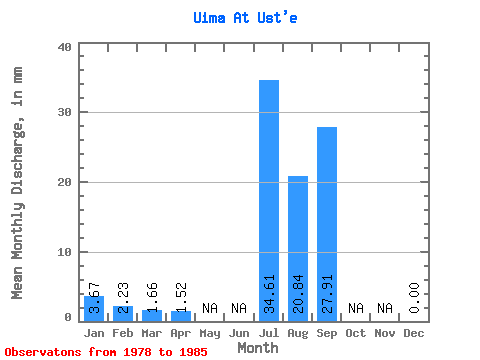
| Units: | m3/s |
| Statistic | Jan | Feb | Mar | Apr | May | Jun | Jul | Aug | Sep | Oct | Nov | Dec | Annual |
|---|---|---|---|---|---|---|---|---|---|---|---|---|---|
| Mean | 3.67 | 2.24 | 1.66 | 1.52 | 34.60 | 20.84 | 27.91 | 0.00 | |||||
| Standard Deviation | 23.81 | 11.08 | 21.46 | 0.00 | |||||||||
| Min | 3.67 | 2.24 | 1.66 | 1.52 | 8.15 | 4.84 | 12.18 | 0.00 | |||||
| Max | 3.67 | 2.24 | 1.66 | 1.52 | 75.68 | 37.84 | 68.92 | 0.00 | |||||
| Coefficient of Variation | 0.69 | 0.53 | 0.77 |
 Return to R-Arctic Net Home Page