|
|
|||||||||||||||||
| Point ID: 9042 | Downloads | Plots | Site Data | Code: 71285 |
|
|
|||||||||||||||||
| Download | |
|---|---|
| Site Descriptor Information | Site Time Series Data |
| Link to all available data | |
|
|
| View: | Statistics | Time Series |
| Units: | m3/s |
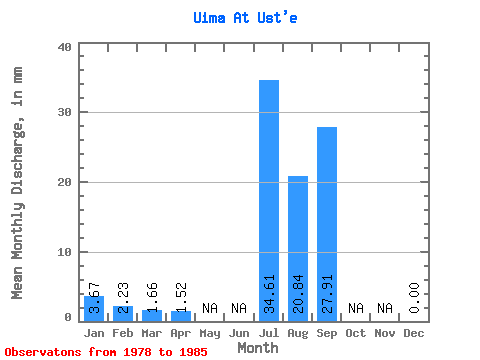
| Statistic | Jan | Feb | Mar | Apr | May | Jun | Jul | Aug | Sep | Oct | Nov | Dec | Annual |
|---|---|---|---|---|---|---|---|---|---|---|---|---|---|
| Mean | 3.67 | 2.24 | 1.66 | 1.52 | 34.60 | 20.84 | 27.91 | 0.00 | |||||
| Standard Deviation | 23.81 | 11.08 | 21.46 | 0.00 | |||||||||
| Min | 3.67 | 2.24 | 1.66 | 1.52 | 8.15 | 4.84 | 12.18 | 0.00 | |||||
| Max | 3.67 | 2.24 | 1.66 | 1.52 | 75.68 | 37.84 | 68.92 | 0.00 | |||||
| Coefficient of Variation | 0.69 | 0.53 | 0.77 |
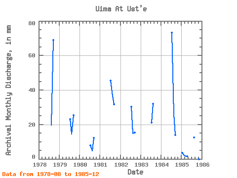
| Year | Jan | Feb | Mar | Apr | May | Jun | Jul | Aug | Sep | Oct | Nov | Dec | Annual | 1978 | 20.38 | 68.92 | 0.00 | 1979 | 23.96 | 15.09 | 25.49 | 0.00 | 1980 | 8.15 | 4.84 | 12.18 | 0.00 | 1981 | 47.02 | 37.84 | 31.64 | 0.00 | 1982 | 31.12 | 15.36 | 15.26 | 0.00 | 1983 | 21.68 | 33.01 | 0.00 | 1984 | 75.68 | 27.23 | 14.00 | 0.00 | 1985 | 3.67 | 2.24 | 1.66 | 1.52 | 12.99 | 0.00 |
|---|
 Return to R-Arctic Net Home Page