|
|
|||||||||||||||||
| Point ID: 9011 | Downloads | Plots | Site Data | Code: 71181 |
|
|
|||||||||||||||||
| Download | |
|---|---|
| Site Descriptor Information | Site Time Series Data |
| Link to all available data | |
| View: | Time Series | All |
| Units: | m3/s |
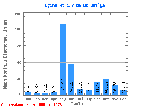
| Statistic | Jan | Feb | Mar | Apr | May | Jun | Jul | Aug | Sep | Oct | Nov | Dec | Annual |
|---|---|---|---|---|---|---|---|---|---|---|---|---|---|
| Mean | 9.45 | 6.94 | 7.11 | 9.19 | 171.44 | 74.82 | 15.63 | 14.03 | 31.60 | 40.66 | 26.22 | 13.31 | 411.59 |
| Standard Deviation | 0.91 | 1.03 | 1.14 | 5.15 | 69.35 | 69.90 | 6.59 | 8.49 | 16.83 | 12.62 | 16.69 | 3.39 | 65.19 |
| Min | 7.60 | 5.28 | 5.28 | 5.48 | 28.45 | 16.32 | 8.37 | 7.98 | 6.11 | 11.46 | 9.72 | 9.53 | 320.53 |
| Max | 10.17 | 8.09 | 8.76 | 21.56 | 239.47 | 219.32 | 26.91 | 29.23 | 60.06 | 57.42 | 59.32 | 18.93 | 473.53 |
| Coefficient of Variation | 0.10 | 0.15 | 0.16 | 0.56 | 0.40 | 0.93 | 0.42 | 0.60 | 0.53 | 0.31 | 0.64 | 0.26 | 0.16 |
 Return to R-Arctic Net Home Page