|
|
|||||||||||||||||
| Point ID: 9011 | Downloads | Plots | Site Data | Code: 71181 |
|
|
|||||||||||||||||
| Download | |
|---|---|
| Site Descriptor Information | Site Time Series Data |
| Link to all available data | |
|
|
| View: | Statistics | Time Series |
| Units: | m3/s |
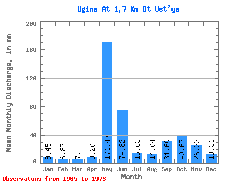
| Statistic | Jan | Feb | Mar | Apr | May | Jun | Jul | Aug | Sep | Oct | Nov | Dec | Annual |
|---|---|---|---|---|---|---|---|---|---|---|---|---|---|
| Mean | 9.45 | 6.94 | 7.11 | 9.19 | 171.44 | 74.82 | 15.63 | 14.03 | 31.60 | 40.66 | 26.22 | 13.31 | 411.59 |
| Standard Deviation | 0.91 | 1.03 | 1.14 | 5.15 | 69.35 | 69.90 | 6.59 | 8.49 | 16.83 | 12.62 | 16.69 | 3.39 | 65.19 |
| Min | 7.60 | 5.28 | 5.28 | 5.48 | 28.45 | 16.32 | 8.37 | 7.98 | 6.11 | 11.46 | 9.72 | 9.53 | 320.53 |
| Max | 10.17 | 8.09 | 8.76 | 21.56 | 239.47 | 219.32 | 26.91 | 29.23 | 60.06 | 57.42 | 59.32 | 18.93 | 473.53 |
| Coefficient of Variation | 0.10 | 0.15 | 0.16 | 0.56 | 0.40 | 0.93 | 0.42 | 0.60 | 0.53 | 0.31 | 0.64 | 0.26 | 0.16 |
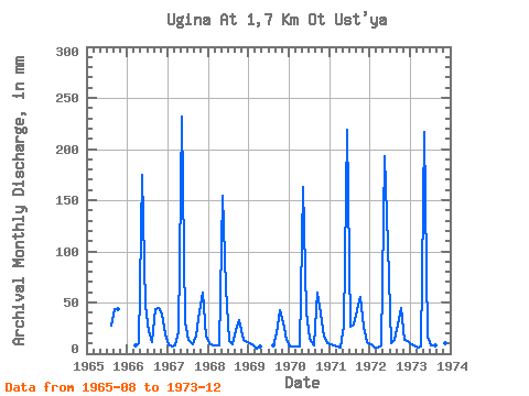
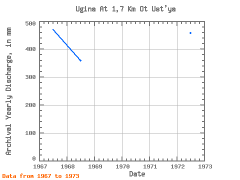
| Year | Jan | Feb | Mar | Apr | May | Jun | Jul | Aug | Sep | Oct | Nov | Dec | Annual | 1965 | 28.20 | 43.37 | 45.32 | 1966 | 7.98 | 9.85 | 180.25 | 46.36 | 22.27 | 11.20 | 43.24 | 46.35 | 38.88 | 18.93 | 1967 | 9.01 | 6.33 | 7.98 | 21.56 | 239.47 | 30.91 | 14.03 | 9.40 | 17.32 | 42.23 | 59.32 | 17.64 | 471.50 | 1968 | 10.17 | 7.86 | 8.76 | 7.85 | 159.65 | 63.55 | 12.49 | 9.66 | 22.93 | 33.48 | 13.83 | 11.46 | 359.48 | 1969 | 10.17 | 7.16 | 5.28 | 7.10 | 8.24 | 20.31 | 43.65 | 30.91 | 13.90 | 1970 | 7.60 | 6.22 | 7.47 | 6.98 | 168.66 | 40.87 | 14.55 | 8.88 | 60.06 | 40.43 | 16.57 | 10.30 | 386.28 | 1971 | 9.79 | 7.62 | 6.82 | 5.48 | 28.45 | 219.32 | 26.91 | 29.23 | 42.37 | 57.42 | 26.67 | 11.59 | 473.53 | 1972 | 9.91 | 5.28 | 6.31 | 7.85 | 199.56 | 106.42 | 10.81 | 13.52 | 28.66 | 45.58 | 13.83 | 13.13 | 458.23 | 1973 | 9.53 | 8.09 | 6.31 | 6.85 | 224.03 | 16.32 | 8.37 | 7.98 | 6.11 | 11.46 | 9.72 | 9.53 | 320.53 |
|---|
 Return to R-Arctic Net Home Page