|
|
|||||||||||||||||
| Point ID: 9 | Downloads | Plots | Site Data | Code: 05AA009 |
|
|
|||||||||||||||||
| Download | |
|---|---|
| Site Descriptor Information | Site Time Series Data |
| Link to all available data | |
| View: | Time Series | All |
| Units: | m3/s |
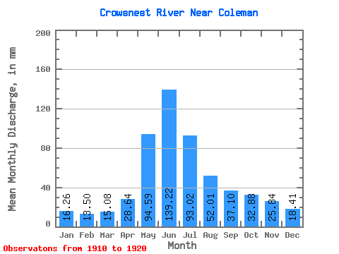
| Statistic | Jan | Feb | Mar | Apr | May | Jun | Jul | Aug | Sep | Oct | Nov | Dec | Annual |
|---|---|---|---|---|---|---|---|---|---|---|---|---|---|
| Mean | 16.27 | 13.62 | 15.08 | 28.64 | 94.58 | 139.22 | 93.01 | 52.01 | 37.09 | 32.87 | 25.85 | 18.41 | 545.30 |
| Standard Deviation | 3.16 | 4.33 | 3.79 | 9.12 | 24.05 | 43.27 | 26.55 | 13.98 | 13.50 | 13.78 | 10.70 | 6.02 | 91.00 |
| Min | 12.20 | 10.01 | 11.24 | 11.27 | 58.05 | 81.95 | 59.81 | 27.90 | 18.00 | 18.28 | 13.47 | 9.65 | 436.55 |
| Max | 20.20 | 23.82 | 21.33 | 44.70 | 129.09 | 209.53 | 149.46 | 68.31 | 67.83 | 58.53 | 43.30 | 27.10 | 682.52 |
| Coefficient of Variation | 0.19 | 0.32 | 0.25 | 0.32 | 0.25 | 0.31 | 0.28 | 0.27 | 0.36 | 0.42 | 0.41 | 0.33 | 0.17 |
 Return to R-Arctic Net Home Page