|
|
|||||||||||||||||
| Point ID: 9 | Downloads | Plots | Site Data | Code: 05AA009 |
|
|
|||||||||||||||||
| Download | |
|---|---|
| Site Descriptor Information | Site Time Series Data |
| Link to all available data | |
|
|
| View: | Statistics | Time Series |
| Units: | m3/s |
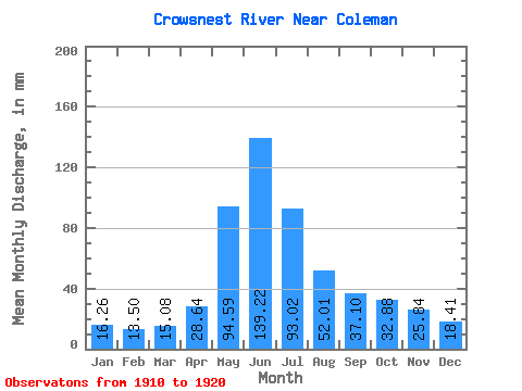
| Statistic | Jan | Feb | Mar | Apr | May | Jun | Jul | Aug | Sep | Oct | Nov | Dec | Annual |
|---|---|---|---|---|---|---|---|---|---|---|---|---|---|
| Mean | 16.27 | 13.62 | 15.08 | 28.64 | 94.58 | 139.22 | 93.01 | 52.01 | 37.09 | 32.87 | 25.85 | 18.41 | 545.30 |
| Standard Deviation | 3.16 | 4.33 | 3.79 | 9.12 | 24.05 | 43.27 | 26.55 | 13.98 | 13.50 | 13.78 | 10.70 | 6.02 | 91.00 |
| Min | 12.20 | 10.01 | 11.24 | 11.27 | 58.05 | 81.95 | 59.81 | 27.90 | 18.00 | 18.28 | 13.47 | 9.65 | 436.55 |
| Max | 20.20 | 23.82 | 21.33 | 44.70 | 129.09 | 209.53 | 149.46 | 68.31 | 67.83 | 58.53 | 43.30 | 27.10 | 682.52 |
| Coefficient of Variation | 0.19 | 0.32 | 0.25 | 0.32 | 0.25 | 0.31 | 0.28 | 0.27 | 0.36 | 0.42 | 0.41 | 0.33 | 0.17 |
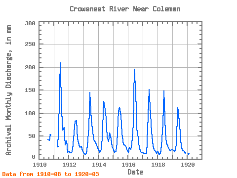
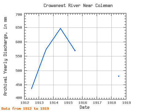
| Year | Jan | Feb | Mar | Apr | May | Jun | Jul | Aug | Sep | Oct | Nov | Dec | Annual | 1910 | 43.62 | 40.51 | 53.56 | 1911 | 27.32 | 115.14 | 209.53 | 105.36 | 64.78 | 67.83 | 31.43 | 38.96 | 15.49 | 1912 | 16.84 | 13.06 | 13.57 | 20.80 | 58.05 | 81.95 | 86.11 | 44.58 | 31.04 | 25.98 | 27.47 | 18.44 | 436.55 | 1913 | 12.72 | 10.01 | 11.24 | 28.71 | 71.52 | 144.81 | 86.92 | 67.99 | 41.91 | 40.09 | 31.20 | 27.10 | 572.91 | 1914 | 19.40 | 13.65 | 20.05 | 44.70 | 129.09 | 114.55 | 91.73 | 49.55 | 38.49 | 58.53 | 43.30 | 26.78 | 647.33 | 1915 | 20.05 | 13.65 | 17.32 | 33.68 | 108.40 | 112.53 | 97.34 | 57.09 | 31.51 | 31.75 | 27.94 | 21.01 | 570.00 | 1916 | 14.05 | 23.82 | 21.33 | 32.28 | 77.29 | 195.56 | 149.46 | 68.31 | 45.32 | 25.82 | 15.68 | 14.16 | 682.52 | 1917 | 13.94 | 11.28 | 12.72 | 11.27 | 96.38 | 151.17 | 99.74 | 60.45 | 28.40 | 20.20 | 16.45 | 12.81 | 533.07 | 1918 | 17.00 | 10.05 | 12.01 | 28.40 | 79.86 | 148.38 | 59.81 | 35.76 | 27.94 | 23.09 | 18.16 | 20.20 | 480.28 | 1919 | 20.20 | 16.22 | 16.04 | 30.58 | 115.46 | 94.52 | 60.62 | 27.90 | 18.00 | 18.28 | 13.47 | 9.65 | 439.70 | 1920 | 12.20 | 10.84 | 11.47 |
|---|
 Return to R-Arctic Net Home Page