|
|
|||||||||||||||||
| Point ID: 898 | Downloads | Plots | Site Data | Other Close Sites | Code: 07FD002 |
|
|
|||||||||||||||||
| Download | |
|---|---|
| Site Descriptor Information | Site Time Series Data |
| Link to all available data | |
| View: | Time Series | All |
| Units: | m3/s |
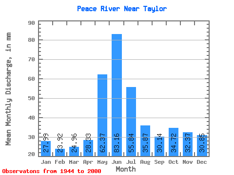
| Statistic | Jan | Feb | Mar | Apr | May | Jun | Jul | Aug | Sep | Oct | Nov | Dec | Annual |
|---|---|---|---|---|---|---|---|---|---|---|---|---|---|
| Mean | 27.99 | 24.12 | 24.96 | 28.33 | 62.36 | 83.16 | 55.83 | 35.87 | 30.14 | 34.72 | 32.37 | 30.85 | 465.18 |
| Standard Deviation | 16.78 | 15.19 | 15.74 | 13.31 | 26.34 | 49.09 | 30.34 | 17.70 | 8.93 | 9.08 | 12.25 | 16.64 | 89.46 |
| Min | 5.82 | 4.65 | 4.77 | 5.45 | 22.12 | 21.20 | 16.57 | 7.70 | 8.49 | 11.67 | 7.23 | 6.23 | 159.32 |
| Max | 54.88 | 46.99 | 51.85 | 57.39 | 133.49 | 217.82 | 157.76 | 99.01 | 50.19 | 54.61 | 52.05 | 54.06 | 689.60 |
| Coefficient of Variation | 0.60 | 0.63 | 0.63 | 0.47 | 0.42 | 0.59 | 0.54 | 0.49 | 0.30 | 0.26 | 0.38 | 0.54 | 0.19 |
| Other Close Sites | ||||||
|---|---|---|---|---|---|---|
| PointID | Latitude | Longitude | Drainage Area | Source | Name | |
| 877 | "PEACE RIVER ABOVE PINE RIVER" | 56.19 | 1897840 | Hydat | ||
| 891 | "BEATTON RIVER NEAR FORT ST. JOHN" | 56.27 | 1885716 | Hydat | ||
 Return to R-Arctic Net Home Page