|
|
|||||||||||||||||
| Point ID: 891 | Downloads | Plots | Site Data | Other Close Sites | Code: 07FC001 |
|
|
|||||||||||||||||
| Download | |
|---|---|
| Site Descriptor Information | Site Time Series Data |
| Link to all available data | |
| View: | Time Series | All |
| Units: | m3/s |
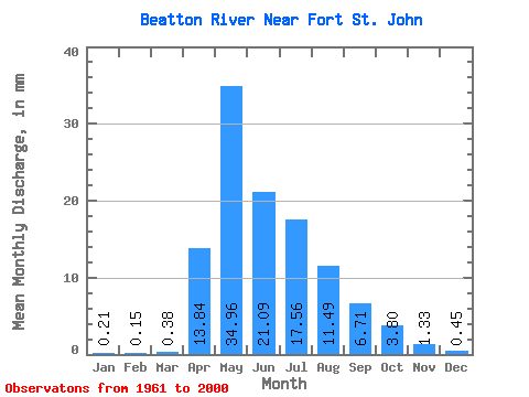
| Statistic | Jan | Feb | Mar | Apr | May | Jun | Jul | Aug | Sep | Oct | Nov | Dec | Annual |
|---|---|---|---|---|---|---|---|---|---|---|---|---|---|
| Mean | 0.21 | 0.15 | 0.38 | 13.84 | 34.96 | 21.09 | 17.56 | 11.49 | 6.71 | 3.80 | 1.33 | 0.45 | 108.61 |
| Standard Deviation | 0.15 | 0.11 | 0.81 | 13.40 | 22.29 | 14.81 | 12.09 | 16.71 | 7.86 | 5.33 | 1.55 | 0.33 | 47.14 |
| Min | 0.03 | 0.01 | 0.05 | 0.43 | 3.38 | 3.79 | 1.61 | 0.57 | 0.27 | 0.50 | 0.31 | 0.05 | 43.77 |
| Max | 0.55 | 0.40 | 4.94 | 57.32 | 89.09 | 67.62 | 56.99 | 71.76 | 35.39 | 32.96 | 8.94 | 1.55 | 276.86 |
| Coefficient of Variation | 0.69 | 0.70 | 2.12 | 0.97 | 0.64 | 0.70 | 0.69 | 1.45 | 1.17 | 1.40 | 1.16 | 0.73 | 0.43 |
| Other Close Sites | ||||||
|---|---|---|---|---|---|---|
| PointID | Latitude | Longitude | Drainage Area | Source | Name | |
| 877 | "PEACE RIVER ABOVE PINE RIVER" | 56.19 | 1897840 | Hydat | ||
| 898 | "PEACE RIVER NEAR TAYLOR" | 56.13 | 1893314 | Hydat | ||
 Return to R-Arctic Net Home Page