|
|
|||||||||||||||||
| Point ID: 8856 | Downloads | Plots | Site Data | Code: 70320 |
|
|
|||||||||||||||||
| Download | |
|---|---|
| Site Descriptor Information | Site Time Series Data |
| Link to all available data | |
| View: | Time Series | All |
| Units: | m3/s |
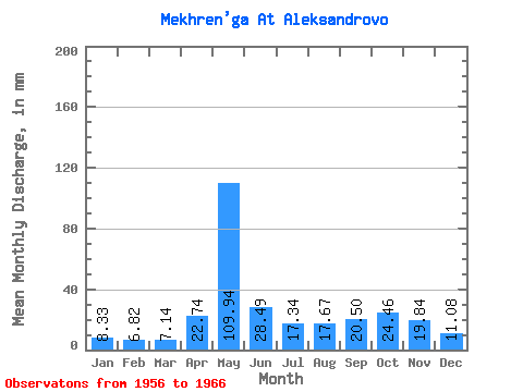
| Statistic | Jan | Feb | Mar | Apr | May | Jun | Jul | Aug | Sep | Oct | Nov | Dec | Annual |
|---|---|---|---|---|---|---|---|---|---|---|---|---|---|
| Mean | 8.33 | 6.88 | 7.13 | 22.74 | 109.93 | 28.49 | 17.34 | 17.67 | 20.50 | 24.45 | 19.84 | 11.08 | 283.60 |
| Standard Deviation | 1.27 | 1.04 | 0.77 | 23.81 | 43.66 | 10.03 | 7.00 | 15.97 | 13.78 | 11.77 | 7.27 | 2.61 | 72.23 |
| Min | 6.16 | 5.67 | 5.96 | 7.18 | 28.74 | 13.38 | 10.79 | 6.81 | 7.96 | 12.41 | 11.23 | 6.81 | 181.48 |
| Max | 10.79 | 8.85 | 8.70 | 86.83 | 178.08 | 44.79 | 33.86 | 56.53 | 48.84 | 54.30 | 34.60 | 15.11 | 391.58 |
| Coefficient of Variation | 0.15 | 0.15 | 0.11 | 1.05 | 0.40 | 0.35 | 0.40 | 0.90 | 0.67 | 0.48 | 0.37 | 0.23 | 0.26 |
 Return to R-Arctic Net Home Page